Pechreada geodata
Pechreada (Mondolkiri) is a seat of a second-order administrative division; located in Cambodia in Asia/Phnom_Penh (GMT+7) time zone. In our database, there are 29 cities with bigger population. Compared to other cities in Cambodia, 58.3% of cities are located further ↓South; 100% of cities are located further ←West and 99.2% of cities have lower elevation than Pechreada. Note1


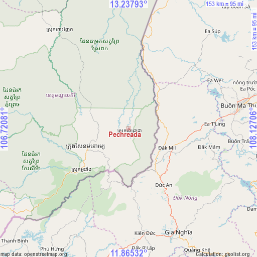
Pechreada GPS coordinates[2]
12° 33' 9.144" North, 107° 25' 26.148" East
| Map corner | latitude | longitude |
|---|---|---|
| Upper-left | 13.23793°, | 106.72081° |
| Center: | 12.55254°, | 107.42393° |
| Lower-right: | 11.86532°, | 108.12706° |
| Map W x H: | 152.6×152.6 km | = 94.8×94.8mi |
| max Lat: | 14.23223° ⇑41.7% North |
| Pechreada: | 12.55254° |
| min Lat: | ⇓58.3% South 10.48291° |
| min Long | Pechreada | max Long |
| 102.37574° | 107.42393° | 107.42393° |
| W 100%⇐ | ⇒0% E |
Elevation
Elevation of Pechreada is 522 m = 1713 ft, and this is 470 m = 1542 ft above average elevation for this country.
| Max E: |
678 m = 2224 ft | 0.8% |
| Pechreada | 522 m 1713 ft | |
| Avg. | 52 m = 171 ft | |
Min E: |
4 m = 13 ft | 99.2% |
See also: Cambodia elevation on elevation.city.
Geographical zone
Pechreada is located in North Torrid zone (between Equator and Tropic of Cancer). Distance of this Northern Tropic circle is 1210.2 km =752 mi to North.| Distance of | km | miles | from Pechreada |
|---|---|---|---|
| North Pole | 8611.4 | 5350.9 | to North |
| Arctic Circle | 6005.5 | 3731.6 | to North |
| Tropic Cancer | 1210.2 | 752 | to North |
| Equator | 1395.7 | 867.2 | to South |


Nearby cities:
15 places around Pechreada: (largest is in red/bold)
• Andoung Meas
146.8 km =91.2 mi,  354°
354°
• Banlung
140.2 km =87.1 mi,  340°
340°
• Bar Kaev
128.1 km =79.6 mi, 349°
• Chhloung
161.3 km =100.2 mi,  258°
258°
• Kaev Seima
71.6 km =44.5 mi,  235°
235°
• Koun Mom
134 km =83.3 mi,  328°
328°
• Kratié
152.7 km =94.9 mi,  267°
267°
• Lumphat
114.9 km =71.4 mi, 335°
• Ou Chum
146.1 km =90.8 mi, 341°
• Ou Ya Dav
124.6 km =77.4 mi,  356°
356°
• Preaek Prasab
152.3 km =94.6 mi, 261°
• Sen Monorom
27.8 km =17.3 mi,  247°
247°
• Sesan
182.2 km =113.2 mi,  307°
307°
• Stung Treng
191.2 km =118.8 mi,  304°
304°
• Veun Sai
171.6 km =106.6 mi, 337°
Sources, notices
• [Note1] Compared only with cities in Cambodia existing in our database
• [Src1] Map data: © OpenStreetMap contributors (CC-BY-SA)
• [Src2] Other city data from geonames.org with taken over terms of usage.
• [Src3] Geographical zone / Annual Mean Temperature by Robert A. Rohde @ Wikipedia
