Sunan geodata
Sunan (Pyongyang) is a populated place; located in North Korea in Asia/Pyongyang (GMT+9) time zone. With population of 36,671 people, there are 28 cities with bigger population in this country. Compared to other cities in North Korea, 70.3% of cities are located further ↑North; 79.1% of cities are located further →East and 56% of cities have higher elevation than Sunan. Note1


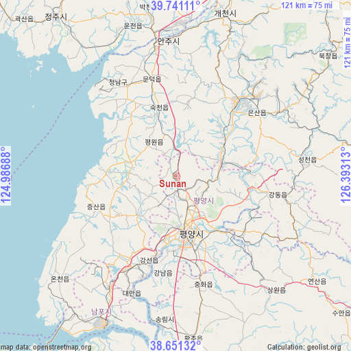
Sunan GPS coordinates[2]
39° 11' 53.988" North, 125° 41' 24" East
| Map corner | latitude | longitude |
|---|---|---|
| Upper-left | 39.74111°, | 124.98688° |
| Center: | 39.19833°, | 125.69° |
| Lower-right: | 38.65132°, | 126.39313° |
| Map W x H: | 121.2×121.2 km | = 75.3×75.3mi |
| max Lat: | 42.95722° ⇑70.3% North |
| Sunan: | 39.19833° |
| min Lat: | ⇓29.7% South 37.90889° |
| min Long | Sunan | max Long |
| 124.39806° | 125.69° | 130.49522° |
| W 20.9%⇐ | ⇒79.1% E |
Elevation
Elevation of Sunan is 34 m = 112 ft, and this is 97.7 m = 321 ft below average elevation for this country.
| Max E: |
1466 m = 4810 ft | 56% |
| Avg. | 131.7 m = 432 ft | |
| Sunan | 34 m = 112 ft | |
Min E: |
1 m = 3 ft | 44% |
See also: North Korea elevation on elevation.city.
Geographical zone
Sunan is located in North temperate zone (between Tropic of Cancer and the Arctic Circle). Distance of this Northern Tropic circle is 1752.5 km =1089 mi to South.| Distance of | km | miles | from Sunan |
|---|---|---|---|
| North Pole | 5648.6 | 3509.9 | to North |
| Arctic Circle | 3042.7 | 1890.6 | to North |
| Tropic Cancer | 1752.5 | 1089 | to South |
| Equator | 4358.4 | 2708.2 | to South |


Nearby cities:
15 places around Sunan: (largest is in red/bold)
• Anju
46.7 km =29 mi,  357°
357°
• Chunghwa
38.4 km =23.9 mi,  165°
165°
• Chŏngju
68.7 km =42.7 mi,  323°
323°
• Hwangju-ŭp
59.2 km =36.8 mi, 172°
• Hŭkkyo-ri
45.3 km =28.1 mi, 168°
• Kangdong-ŭp
35.6 km =22.1 mi,  100°
100°
• Namp’o
56.8 km =35.3 mi,  205°
205°
• Pyongyang
19.1 km =11.9 mi,  163°
163°
• P’yŏngsŏng
16.6 km =10.3 mi,  71°
71°
• Sil-li
37.8 km =23.5 mi,  330°
330°
• Sinanju
45 km =28 mi,  351°
351°
• Songnim
49.5 km =30.8 mi,  184°
184°
• Sunch’ŏn
33.3 km =20.7 mi,  38°
38°
• Sŭngho 1-tong
33.9 km =21.1 mi,  132°
132°
• Yonggang-ŭp
44.4 km =27.6 mi, 211°
Sources, notices
• [Note1] Compared only with cities in North Korea existing in our database
• [Src1] Map data: © OpenStreetMap contributors (CC-BY-SA)
• [Src2] Other city data from geonames.org with taken over terms of usage.
• [Src3] Geographical zone / Annual Mean Temperature by Robert A. Rohde @ Wikipedia
