Anju geodata
Anju (South Pyongan) is a populated place; located in North Korea in Asia/Pyongyang (GMT+9) time zone. With population of 50,196 people, there are 23 cities with bigger population in this country. Compared to other cities in North Korea, 63.7% of cities are located further ↑North; 80.2% of cities are located further →East and 79.1% of cities have higher elevation than Anju. Note1


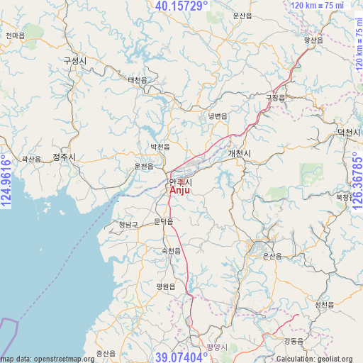
Anju GPS coordinates[2]
39° 37' 4.008" North, 125° 39' 52.992" East
| Map corner | latitude | longitude |
|---|---|---|
| Upper-left | 40.15729°, | 124.9616° |
| Center: | 39.61778°, | 125.66472° |
| Lower-right: | 39.07404°, | 126.36785° |
| Map W x H: | 120.4×120.4 km | = 74.8×74.8mi |
| max Lat: | 42.95722° ⇑63.7% North |
| Anju: | 39.61778° |
| min Lat: | ⇓36.3% South 37.90889° |
| min Long | Anju | max Long |
| 124.39806° | 125.66472° | 130.49522° |
| W 19.8%⇐ | ⇒80.2% E |
Elevation
Elevation of Anju is 16 m = 52 ft, and this is 115.7 m = 380 ft below average elevation for this country.
| Max E: |
1466 m = 4810 ft | 79.1% |
| Avg. | 131.7 m = 432 ft | |
| Anju | 16 m = 52 ft | |
Min E: |
1 m = 3 ft | 20.9% |
See also: Anju elevation on elevation.city.
Geographical zone
Anju is located in North temperate zone (between Tropic of Cancer and the Arctic Circle). Distance of this Northern Tropic circle is 1799.2 km =1118 mi to South.| Distance of | km | miles | from Anju |
|---|---|---|---|
| North Pole | 5602 | 3480.9 | to North |
| Arctic Circle | 2996.1 | 1861.7 | to North |
| Tropic Cancer | 1799.2 | 1118 | to South |
| Equator | 4405.1 | 2737.2 | to South |


Nearby cities:
15 places around Anju: (largest is in red/bold)
• Chŏngju
39.8 km =24.7 mi,  282°
282°
• Kangdong-ŭp
64.6 km =40.1 mi,  144°
144°
• Kujang-ŭp
41.8 km =26 mi,  48°
48°
• Kusŏng
54 km =33.6 mi,  318°
318°
• Kwaksan
50.4 km =31.3 mi, 278°
• Panghyŏn-dong
47 km =29.2 mi,  309°
309°
• Pukchil-lodongjagu
65.3 km =40.6 mi,  6°
6°
• Pyongyang
65.4 km =40.6 mi,  173°
173°
• P’yŏngsŏng
45 km =28 mi,  156°
156°
• Sil-li
21.3 km =13.2 mi,  230°
230°
• Sinanju
5.2 km =3.2 mi,  245°
245°
• Sunan
46.7 km =29 mi,  177°
177°
• Sunch’ŏn
30.9 km =19.2 mi,  131°
131°
• Sŭngho 1-tong
74.7 km =46.4 mi, 158°
• Yŏngbyŏn
24.8 km =15.4 mi,  28°
28°
Sources, notices
• [Note1] Compared only with cities in North Korea existing in our database
• [Src1] Map data: © OpenStreetMap contributors (CC-BY-SA)
• [Src2] Other city data from geonames.org with taken over terms of usage.
• [Src3] Geographical zone / Annual Mean Temperature by Robert A. Rohde @ Wikipedia
