Sil-li geodata
Sil-li (South Pyongan) is a populated place; located in North Korea in Asia/Pyongyang (GMT+9) time zone. With population of 19,463 people, there are 52 cities with bigger population in this country. Compared to other cities in North Korea, 65.9% of cities are located further ↑North; 86.8% of cities are located further →East and 89% of cities have higher elevation than Sil-li. Note1


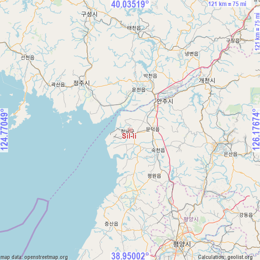
Sil-li GPS coordinates[2]
39° 29' 40.992" North, 125° 28' 24.996" East
| Map corner | latitude | longitude |
|---|---|---|
| Upper-left | 40.03519°, | 124.77049° |
| Center: | 39.49472°, | 125.47361° |
| Lower-right: | 38.95002°, | 126.17674° |
| Map W x H: | 120.7×120.7 km | = 75×75mi |
| max Lat: | 42.95722° ⇑65.9% North |
| Sil-li: | 39.49472° |
| min Lat: | ⇓34.1% South 37.90889° |
| min Long | Sil-li | max Long |
| 124.39806° | 125.47361° | 130.49522° |
| W 13.2%⇐ | ⇒86.8% E |
Elevation
Elevation of Sil-li is 9 m = 30 ft, and this is 122.7 m = 403 ft below average elevation for this country.
| Max E: |
1466 m = 4810 ft | 89% |
| Avg. | 131.7 m = 432 ft | |
| Sil-li | 9 m = 30 ft | |
Min E: |
1 m = 3 ft | 11% |
See also: North Korea elevation on elevation.city.
Geographical zone
Sil-li is located in North temperate zone (between Tropic of Cancer and the Arctic Circle). Distance of this Northern Tropic circle is 1785.5 km =1109.5 mi to South.| Distance of | km | miles | from Sil-li |
|---|---|---|---|
| North Pole | 5615.7 | 3489.4 | to North |
| Arctic Circle | 3009.8 | 1870.2 | to North |
| Tropic Cancer | 1785.5 | 1109.5 | to South |
| Equator | 4391.4 | 2728.7 | to South |


Nearby cities:
15 places around Sil-li: (largest is in red/bold)
• Anju
21.3 km =13.2 mi,  50°
50°
• Chŏngju
31.6 km =19.6 mi,  314°
314°
• Kangdong-ŭp
66.3 km =41.2 mi,  126°
126°
• Kujang-ŭp
63.1 km =39.2 mi, 48°
• Kusŏng
57.5 km =35.7 mi,  340°
340°
• Kwaksan
39.8 km =24.7 mi,  302°
302°
• Panghyŏn-dong
48 km =29.8 mi, 335°
• Pyongyang
56.7 km =35.2 mi,  154°
154°
• P’yŏngsŏng
44 km =27.3 mi, 128°
• Sinanju
16.4 km =10.2 mi, 45°
• Sunan
37.8 km =23.5 mi, 150°
• Sunch’ŏn
40 km =24.9 mi,  100°
100°
• Sŭngho 1-tong
70.8 km =44 mi,  142°
142°
• Yonggang-ŭp
71.1 km =44.2 mi,  183°
183°
• Yŏngbyŏn
45.3 km =28.1 mi,  38°
38°
Sources, notices
• [Note1] Compared only with cities in North Korea existing in our database
• [Src1] Map data: © OpenStreetMap contributors (CC-BY-SA)
• [Src2] Other city data from geonames.org with taken over terms of usage.
• [Src3] Geographical zone / Annual Mean Temperature by Robert A. Rohde @ Wikipedia
