Kujang-ŭp geodata
Kujang-ŭp (P'yŏngan-bukto) is a populated place; located in North Korea in Asia/Pyongyang (GMT+9) time zone. With population of 19,522 people, there are 51 cities with bigger population in this country. Compared to other cities in North Korea, 57.1% of cities are located further ↑North; 64.8% of cities are located further →East and 57.1% of cities have lower elevation than Kujang-ŭp. Note1


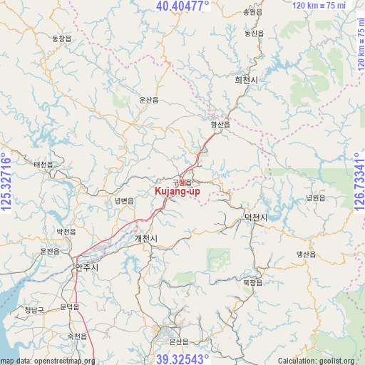
Kujang-ŭp GPS coordinates[2]
39° 52' 1.992" North, 126° 1' 49.008" East
| Map corner | latitude | longitude |
|---|---|---|
| Upper-left | 40.40477°, | 125.32716° |
| Center: | 39.86722°, | 126.03028° |
| Lower-right: | 39.32543°, | 126.73341° |
| Map W x H: | 120×120 km | = 74.6×74.6mi |
| max Lat: | 42.95722° ⇑57.1% North |
| Kujang-ŭp: | 39.86722° |
| min Lat: | ⇓42.9% South 37.90889° |
| min Long | Kujang-ŭp | max Long |
| 124.39806° | 126.03028° | 130.49522° |
| W 35.2%⇐ | ⇒64.8% E |
Elevation
Elevation of Kujang-ŭp is 66 m = 217 ft, and this is 65.7 m = 216 ft below average elevation for this country.
| Max E: |
1466 m = 4810 ft | 42.9% |
| Avg. | 131.7 m = 432 ft | |
| Kujang-ŭp | 66 m = 217 ft | |
Min E: |
1 m = 3 ft | 57.1% |
See also: North Korea elevation on elevation.city.
Geographical zone
Kujang-ŭp is located in North temperate zone (between Tropic of Cancer and the Arctic Circle). Distance of this Northern Tropic circle is 1826.9 km =1135.2 mi to South.| Distance of | km | miles | from Kujang-ŭp |
|---|---|---|---|
| North Pole | 5574.2 | 3463.6 | to North |
| Arctic Circle | 2968.4 | 1844.5 | to North |
| Tropic Cancer | 1826.9 | 1135.2 | to South |
| Equator | 4432.8 | 2754.4 | to South |


Nearby cities:
15 places around Kujang-ŭp: (largest is in red/bold)
• Anju
41.8 km =26 mi,  228°
228°
• Chŏngju
72.7 km =45.2 mi,  254°
254°
• Kangdong-ŭp
80.8 km =50.2 mi,  175°
175°
• Kusŏng
68.2 km =42.4 mi,  280°
280°
• Kwaksan
83.4 km =51.8 mi,  256°
256°
• Panghyŏn-dong
67.4 km =41.9 mi,  271°
271°
• Pukchil-lodongjagu
44.3 km =27.5 mi,  327°
327°
• Pyongyang
95.6 km =59.4 mi,  194°
194°
• P’yŏngsŏng
70.4 km =43.7 mi, 191°
• Sil-li
63.1 km =39.2 mi, 228°
• Sinanju
46.8 km =29.1 mi, 230°
• Sunan
79.9 km =49.6 mi,  201°
201°
• Sunch’ŏn
49.1 km =30.5 mi, 189°
• Sŭngho 1-tong
97.5 km =60.6 mi, 182°
• Yŏngbyŏn
20.2 km =12.6 mi, 252°
Sources, notices
• [Note1] Compared only with cities in North Korea existing in our database
• [Src1] Map data: © OpenStreetMap contributors (CC-BY-SA)
• [Src2] Other city data from geonames.org with taken over terms of usage.
• [Src3] Geographical zone / Annual Mean Temperature by Robert A. Rohde @ Wikipedia
