Bucheon-si geodata
Bucheon-si (Gyeonggi-do) is a populated place; located in South Korea in Asia/Seoul (GMT+9) time zone. With population of 850,731 people, there are 10 cities with bigger population in this country. Compared to other cities in South Korea, 80.1% of cities are located further ↓South; 78% of cities are located further →East and 84.3% of cities have higher elevation than Bucheon-si. Note1


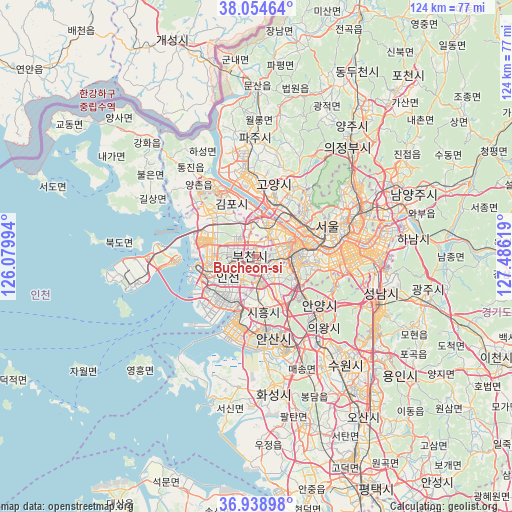
Bucheon-si GPS coordinates[2]
37° 29' 56.004" North, 126° 46' 59.016" East
| Map corner | latitude | longitude |
|---|---|---|
| Upper-left | 38.05464°, | 126.07994° |
| Center: | 37.49889°, | 126.78306° |
| Lower-right: | 36.93898°, | 127.48619° |
| Map W x H: | 124×124 km | = 77.1×77.1mi |
| max Lat: | 38.37881° ⇑19.9% North |
| Bucheon-si: | 37.49889° |
| min Lat: | ⇓80.1% South 33.25333° |
| min Long | Bucheon-si | max Long |
| 126.10863° | 126.78306° | 129.55377° |
| W 22%⇐ | ⇒78% E |
Elevation
Elevation of Bucheon-si is 14 m = 46 ft, and this is 56.4 m = 185 ft below average elevation for this country.
| Max E: |
691 m = 2267 ft | 84.3% |
| Avg. | 70.4 m = 231 ft | |
| Bucheon-si | 14 m = 46 ft | |
Min E: |
1 m = 3 ft | 15.7% |
See also: Bucheon-si elevation on elevation.city.
Geographical zone
Bucheon-si is located in North temperate zone (between Tropic of Cancer and the Arctic Circle). Distance of this Northern Tropic circle is 1563.6 km =971.6 mi to South.| Distance of | km | miles | from Bucheon-si |
|---|---|---|---|
| North Pole | 5837.6 | 3627.3 | to North |
| Arctic Circle | 3231.7 | 2008.1 | to North |
| Tropic Cancer | 1563.6 | 971.6 | to South |
| Equator | 4169.5 | 2590.8 | to South |


Nearby cities:
15 places around Bucheon-si: (largest is in red/bold)
• Ansan-si
19.8 km =12.3 mi,  170°
170°
• Anyang-si
17.4 km =10.8 mi,  132°
132°
• Bupyeong
5.4 km =3.4 mi,  277°
277°
• Goyang-si
18.1 km =11.2 mi,  14°
14°
• Gwangtan
31.9 km =19.8 mi, 10°
• Haseong
27.9 km =17.3 mi,  331°
331°
• Incheon
8.3 km =5.2 mi,  235°
235°
• Jangheung
28 km =17.4 mi,  29°
29°
• Kwangmyŏng
7.7 km =4.8 mi,  108°
108°
• Paripark
9.2 km =5.7 mi,  64°
64°
• Seoul
18.8 km =11.7 mi,  66°
66°
• Suwon
30.5 km =19 mi,  139°
139°
• Tongjin
26.9 km =16.7 mi,  322°
322°
• Wolgot
31.5 km =19.6 mi, 320°
• Yongsan-dong
18.4 km =11.4 mi, 74°
Sources, notices
• [Note1] Compared only with cities in South Korea existing in our database
• [Src1] Map data: © OpenStreetMap contributors (CC-BY-SA)
• [Src2] Other city data from geonames.org with taken over terms of usage.
• [Src3] Geographical zone / Annual Mean Temperature by Robert A. Rohde @ Wikipedia
