Incheon geodata
Incheon is a seat of a first-order administrative division; located in South Korea in Asia/Seoul (GMT+9) time zone. With population of 2,628,000 people, there are 2 cities with bigger population in this country. Compared to other cities in South Korea, 79% of cities are located further ↓South; 80.8% of cities are located further →East and 50.3% of cities have lower elevation than Incheon. Note1


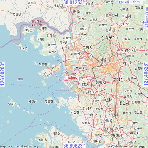
Incheon GPS coordinates[2]
37° 27' 23.256" North, 126° 42' 18.54" East
| Map corner | latitude | longitude |
|---|---|---|
| Upper-left | 38.01253°, | 126.00203° |
| Center: | 37.45646°, | 126.70515° |
| Lower-right: | 36.89623°, | 127.40828° |
| Map W x H: | 124.1×124.1 km | = 77.1×77.1mi |
| max Lat: | 38.37881° ⇑21% North |
| Incheon: | 37.45646° |
| min Lat: | ⇓79% South 33.25333° |
| min Long | Incheon | max Long |
| 126.10863° | 126.70515° | 129.55377° |
| W 19.2%⇐ | ⇒80.8% E |
Elevation
Elevation of Incheon is 43 m = 141 ft, and this is 27.4 m = 90 ft below average elevation for this country.
| Max E: |
691 m = 2267 ft | 49.7% |
| Avg. | 70.4 m = 231 ft | |
| Incheon | 43 m = 141 ft | |
Min E: |
1 m = 3 ft | 50.3% |
See also: Incheon elevation on elevation.city.
Geographical zone
Incheon is located in North temperate zone (between Tropic of Cancer and the Arctic Circle). Distance of this Northern Tropic circle is 1558.8 km =968.6 mi to South.| Distance of | km | miles | from Incheon |
|---|---|---|---|
| North Pole | 5842.3 | 3630.2 | to North |
| Arctic Circle | 3236.4 | 2011 | to North |
| Tropic Cancer | 1558.8 | 968.6 | to South |
| Equator | 4164.8 | 2587.9 | to South |


Nearby cities:
15 places around Incheon: (largest is in red/bold)
• Ansan-si
18 km =11.2 mi,  145°
145°
• Anyang-si
20.8 km =12.9 mi,  109°
109°
• Bucheon-si
8.3 km =5.2 mi,  55°
55°
• Bupyeong
5.6 km =3.5 mi,  15°
15°
• Goyang-si
25 km =15.5 mi,  27°
27°
• Haseong
30 km =18.6 mi,  347°
347°
• Hwaseong-si
29.5 km =18.3 mi,  160°
160°
• Kwangmyŏng
14.4 km =8.9 mi,  80°
80°
• Paripark
17.5 km =10.9 mi, 60°
• Seonwon
34.5 km =21.4 mi,  325°
325°
• Seoul
27 km =16.8 mi, 63°
• Suwon
32.5 km =20.2 mi,  124°
124°
• Tongjin
27.8 km =17.3 mi,  340°
340°
• Wolgot
31.8 km =19.8 mi, 335°
• Yongsan-dong
26.4 km =16.4 mi,  68°
68°
Sources, notices
• [Note1] Compared only with cities in South Korea existing in our database
• [Src1] Map data: © OpenStreetMap contributors (CC-BY-SA)
• [Src2] Other city data from geonames.org with taken over terms of usage.
• [Src3] Geographical zone / Annual Mean Temperature by Robert A. Rohde @ Wikipedia
