Ansan-si geodata
Ansan-si (Gyeonggi-do) is a populated place; located in South Korea in Asia/Seoul (GMT+9) time zone. With population of 650,728 people, there are 12 cities with bigger population in this country. Compared to other cities in South Korea, 76.6% of cities are located further ↓South; 75.9% of cities are located further →East and 81.8% of cities have higher elevation than Ansan-si. Note1


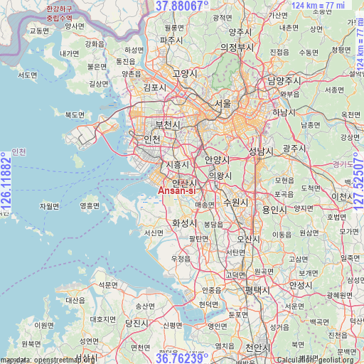
Ansan-si GPS coordinates[2]
37° 19' 24.996" North, 126° 49' 18.984" East
| Map corner | latitude | longitude |
|---|---|---|
| Upper-left | 37.88067°, | 126.11882° |
| Center: | 37.32361°, | 126.82194° |
| Lower-right: | 36.76239°, | 127.52507° |
| Map W x H: | 124.3×124.3 km | = 77.2×77.2mi |
| max Lat: | 38.37881° ⇑23.4% North |
| Ansan-si: | 37.32361° |
| min Lat: | ⇓76.6% South 33.25333° |
| min Long | Ansan-si | max Long |
| 126.10863° | 126.82194° | 129.55377° |
| W 24.1%⇐ | ⇒75.9% E |
Elevation
Elevation of Ansan-si is 15 m = 49 ft, and this is 55.4 m = 182 ft below average elevation for this country.
| Max E: |
691 m = 2267 ft | 81.8% |
| Avg. | 70.4 m = 231 ft | |
| Ansan-si | 15 m = 49 ft | |
Min E: |
1 m = 3 ft | 18.2% |
See also: Ansan-si elevation on elevation.city.
Geographical zone
Ansan-si is located in North temperate zone (between Tropic of Cancer and the Arctic Circle). Distance of this Northern Tropic circle is 1544.1 km =959.5 mi to South.| Distance of | km | miles | from Ansan-si |
|---|---|---|---|
| North Pole | 5857.1 | 3639.4 | to North |
| Arctic Circle | 3251.2 | 2020.2 | to North |
| Tropic Cancer | 1544.1 | 959.5 | to South |
| Equator | 4150 | 2578.7 | to South |


Nearby cities:
15 places around Ansan-si: (largest is in red/bold)
• Anyang-si
12 km =7.5 mi,  50°
50°
• Bucheon-si
19.8 km =12.3 mi,  350°
350°
• Bupyeong
22 km =13.7 mi,  336°
336°
• Goyang-si
37 km =23 mi,  1°
1°
• Guri-si
41.5 km =25.8 mi,  42°
42°
• Gwangju
39.6 km =24.6 mi,  75°
75°
• Hwaseong-si
13 km =8.1 mi,  181°
181°
• Incheon
18 km =11.2 mi,  325°
325°
• Kwangmyŏng
17.5 km =10.9 mi,  12°
12°
• Osan
29.1 km =18.1 mi,  130°
130°
• Paripark
24 km =14.9 mi, 11°
• Seongnam-si
30.7 km =19.1 mi,  65°
65°
• Seoul
30.3 km =18.8 mi,  27°
27°
• Suwon
16.9 km =10.5 mi,  102°
102°
• Yongsan-dong
28.4 km =17.6 mi, 30°
Sources, notices
• [Note1] Compared only with cities in South Korea existing in our database
• [Src1] Map data: © OpenStreetMap contributors (CC-BY-SA)
• [Src2] Other city data from geonames.org with taken over terms of usage.
• [Src3] Geographical zone / Annual Mean Temperature by Robert A. Rohde @ Wikipedia
