Kwangmyŏng geodata
Kwangmyŏng (Gyeonggi-do) is a populated place; located in South Korea in Asia/Seoul (GMT+9) time zone. With population of 357,545 people, there are 22 cities with bigger population in this country. Compared to other cities in South Korea, 79.4% of cities are located further ↓South; 73.8% of cities are located further →East and 60.8% of cities have higher elevation than Kwangmyŏng. Note1


Kwangmyŏng GPS coordinates[2]
37° 28' 37.992" North, 126° 51' 59.004" East
| Map corner | latitude | longitude |
|---|---|---|
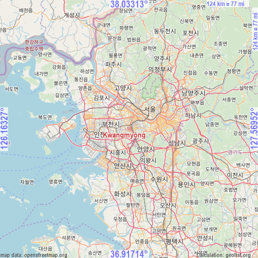
| Upper-left | 38.03313°, | 126.16327° |
| Center: | 37.47722°, | 126.86639° |
| Lower-right: | 36.91714°, | 127.56952° |
| Map W x H: | 124.1×124.1 km | = 77.1×77.1mi |
| max Lat: | 38.37881° ⇑20.6% North |
| Kwangmyŏng: | 37.47722° |
| min Lat: | ⇓79.4% South 33.25333° |
| min Long | Kwangmyŏng | max Long |
| 126.10863° | 126.86639° | 129.55377° |
| W 26.2%⇐ | ⇒73.8% E |
Elevation
Elevation of Kwangmyŏng is 30 m = 98 ft, and this is 40.4 m = 133 ft below average elevation for this country.
| Max E: |
691 m = 2267 ft | 60.8% |
| Avg. | 70.4 m = 231 ft | |
| Kwangmyŏng | 30 m = 98 ft | |
Min E: |
1 m = 3 ft | 39.2% |
See also: Kwangmyŏng elevation on elevation.city.
Geographical zone
Kwangmyŏng is located in North temperate zone (between Tropic of Cancer and the Arctic Circle). Distance of this Northern Tropic circle is 1561.2 km =970.1 mi to South.| Distance of | km | miles | from Kwangmyŏng |
|---|---|---|---|
| North Pole | 5840 | 3628.8 | to North |
| Arctic Circle | 3234.1 | 2009.6 | to North |
| Tropic Cancer | 1561.2 | 970.1 | to South |
| Equator | 4167.1 | 2589.3 | to South |


Nearby cities:
15 places around Kwangmyŏng: (largest is in red/bold)
• Ansan-si
17.5 km =10.9 mi,  192°
192°
• Anyang-si
10.8 km =6.7 mi,  150°
150°
• Bucheon-si
7.7 km =4.8 mi,  288°
288°
• Bupyeong
13.1 km =8.1 mi,  283°
283°
• Goyang-si
20.1 km =12.5 mi,  352°
352°
• Guri-si
27.6 km =17.1 mi,  60°
60°
• Hanam
30.7 km =19.1 mi,  76°
76°
• Hwaseong-si
30.4 km =18.9 mi, 188°
• Incheon
14.4 km =8.9 mi,  260°
260°
• Jangheung
27.5 km =17.1 mi,  13°
13°
• Paripark
6.5 km =4 mi, 7°
• Seongnam-si
24.3 km =15.1 mi,  100°
100°
• Seoul
14 km =8.7 mi,  45°
45°
• Suwon
24.2 km =15 mi, 148°
• Yongsan-dong
12.8 km =8 mi, 54°
Sources, notices
• [Note1] Compared only with cities in South Korea existing in our database
• [Src1] Map data: © OpenStreetMap contributors (CC-BY-SA)
• [Src2] Other city data from geonames.org with taken over terms of usage.
• [Src3] Geographical zone / Annual Mean Temperature by Robert A. Rohde @ Wikipedia
