Pohang geodata
Pohang (Gyeongsangbuk-do) is a seat of a second-order administrative division; located in South Korea in Asia/Seoul (GMT+9) time zone. With population of 500,000 people, there are 16 cities with bigger population in this country. Compared to other cities in South Korea, 51.4% of cities are located further ↓South; 98.6% of cities are located further ←West and 98.6% of cities have higher elevation than Pohang. Note1


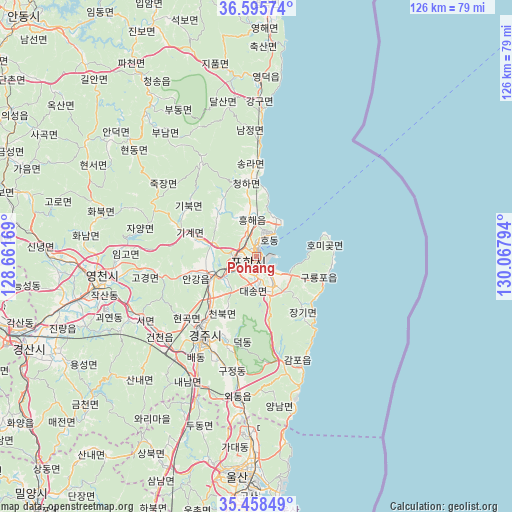
Pohang GPS coordinates[2]
36° 1' 45.012" North, 129° 21' 53.316" East
| Map corner | latitude | longitude |
|---|---|---|
| Upper-left | 36.59574°, | 128.66169° |
| Center: | 36.02917°, | 129.36481° |
| Lower-right: | 35.45849°, | 130.06794° |
| Map W x H: | 126.5×126.5 km | = 78.6×78.6mi |
| max Lat: | 38.37881° ⇑48.6% North |
| Pohang: | 36.02917° |
| min Lat: | ⇓51.4% South 33.25333° |
| min Long | Pohang | max Long |
| 126.10863° | 129.36481° | 129.55377° |
| W 98.6%⇐ | ⇒1.4% E |
Elevation
Elevation of Pohang is 5 m = 16 ft, and this is 65.4 m = 215 ft below average elevation for this country.
| Max E: |
691 m = 2267 ft | 98.6% |
| Avg. | 70.4 m = 231 ft | |
| Pohang | 5 m = 16 ft | |
Min E: |
1 m = 3 ft | 1.4% |
See also: Pohang elevation on elevation.city.
Geographical zone
Pohang is located in North temperate zone (between Tropic of Cancer and the Arctic Circle). Distance of this Northern Tropic circle is 1400.1 km =870 mi to South.| Distance of | km | miles | from Pohang |
|---|---|---|---|
| North Pole | 6001 | 3728.8 | to North |
| Arctic Circle | 3395.1 | 2109.6 | to North |
| Tropic Cancer | 1400.1 | 870 | to South |
| Equator | 4006.1 | 2489.3 | to South |


Nearby cities:
15 places around Pohang: (largest is in red/bold)
• Cheongha
18.9 km =11.7 mi,  352°
352°
• Cheongsong gun
52.8 km =32.8 mi,  328°
328°
• Eisen
39.6 km =24.6 mi,  260°
260°
• Gampo
27.7 km =17.2 mi,  153°
153°
• Guryongpo
17.5 km =10.9 mi,  104°
104°
• Gyeongju
24.9 km =15.5 mi,  213°
213°
• Gyeongsan-si
60.9 km =37.8 mi,  247°
247°
• Hayang
50.7 km =31.5 mi, 255°
• Heunghae
9.1 km =5.7 mi, 348°
• Ocheon
7.8 km =4.8 mi, 146°
• Singwang
14.4 km =8.9 mi,  320°
320°
• Ulsan
54.9 km =34.1 mi,  184°
184°
• Ungsang
71.5 km =44.4 mi,  194°
194°
• Yeongdeok
42.8 km =26.6 mi,  0°
0°
• Yeonil
4 km =2.5 mi,  197°
197°
Sources, notices
• [Note1] Compared only with cities in South Korea existing in our database
• [Src1] Map data: © OpenStreetMap contributors (CC-BY-SA)
• [Src2] Other city data from geonames.org with taken over terms of usage.
• [Src3] Geographical zone / Annual Mean Temperature by Robert A. Rohde @ Wikipedia
