Ulsan geodata
Ulsan is a seat of a first-order administrative division; located in South Korea in Asia/Seoul (GMT+9) time zone. With population of 962,865 people, there are 9 cities with bigger population in this country. Compared to other cities in South Korea, 59.8% of cities are located further ↑North; 97.2% of cities are located further ←West and 92% of cities have higher elevation than Ulsan. Note1


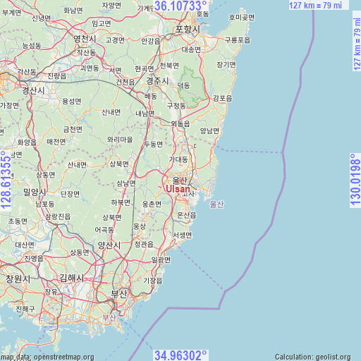
Ulsan GPS coordinates[2]
35° 32' 13.992" North, 129° 19' 0.012" East
| Map corner | latitude | longitude |
|---|---|---|
| Upper-left | 36.10733°, | 128.61355° |
| Center: | 35.53722°, | 129.31667° |
| Lower-right: | 34.96302°, | 130.0198° |
| Map W x H: | 127.2×127.2 km | = 79×79mi |
| max Lat: | 38.37881° ⇑59.8% North |
| Ulsan: | 35.53722° |
| min Lat: | ⇓40.2% South 33.25333° |
| min Long | Ulsan | max Long |
| 126.10863° | 129.31667° | 129.55377° |
| W 97.2%⇐ | ⇒2.8% E |
Elevation
Elevation of Ulsan is 10 m = 33 ft, and this is 60.4 m = 198 ft below average elevation for this country.
| Max E: |
691 m = 2267 ft | 92% |
| Avg. | 70.4 m = 231 ft | |
| Ulsan | 10 m = 33 ft | |
Min E: |
1 m = 3 ft | 8% |
See also: Ulsan elevation on elevation.city.
Geographical zone
Ulsan is located in North temperate zone (between Tropic of Cancer and the Arctic Circle). Distance of this Northern Tropic circle is 1345.4 km =836 mi to South.| Distance of | km | miles | from Ulsan |
|---|---|---|---|
| North Pole | 6055.7 | 3762.8 | to North |
| Arctic Circle | 3449.8 | 2143.6 | to North |
| Tropic Cancer | 1345.4 | 836 | to South |
| Equator | 3951.4 | 2455.3 | to South |


Nearby cities:
15 places around Ulsan: (largest is in red/bold)
• Busan
55 km =34.2 mi,  208°
208°
• Dongnae
42.8 km =26.6 mi, 209°
• Gampo
34.2 km =21.3 mi,  29°
29°
• Gijang
33.9 km =21.1 mi,  195°
195°
• Guryongpo
54.7 km =34 mi,  23°
23°
• Gyeongju
35.3 km =21.9 mi,  344°
344°
• Ilgwang
31.3 km =19.4 mi,  193°
193°
• Jangan
25.8 km =16 mi, 195°
• Kimhae
51.9 km =32.2 mi,  229°
229°
• Miryang
51.6 km =32.1 mi,  264°
264°
• Ocheon
48.9 km =30.4 mi,  10°
10°
• Pohang
54.9 km =34.1 mi,  4°
4°
• Ungsang
19.8 km =12.3 mi,  222°
222°
• Yangsan
33.6 km =20.9 mi, 229°
• Yeonil
51 km =31.7 mi, 3°
Sources, notices
• [Note1] Compared only with cities in South Korea existing in our database
• [Src1] Map data: © OpenStreetMap contributors (CC-BY-SA)
• [Src2] Other city data from geonames.org with taken over terms of usage.
• [Src3] Geographical zone / Annual Mean Temperature by Robert A. Rohde @ Wikipedia
