Guryongpo geodata
Guryongpo (Gyeongsangbuk-do) is a seat of a third-order administrative division; located in South Korea in Asia/Seoul (GMT+9) time zone. In our database, there are 128 cities with bigger population. Compared to other cities in South Korea, 50.3% of cities are located further ↓South; 100% of cities are located further ←West and 95.1% of cities have higher elevation than Guryongpo. Note1


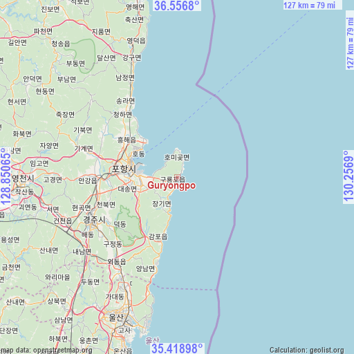
Guryongpo GPS coordinates[2]
35° 59' 23.784" North, 129° 33' 13.572" East
| Map corner | latitude | longitude |
|---|---|---|
| Upper-left | 36.5568°, | 128.85065° |
| Center: | 35.98994°, | 129.55377° |
| Lower-right: | 35.41898°, | 130.2569° |
| Map W x H: | 126.5×126.5 km | = 78.6×78.6mi |
| max Lat: | 38.37881° ⇑49.7% North |
| Guryongpo: | 35.98994° |
| min Lat: | ⇓50.3% South 33.25333° |
| min Long | Guryongpo | max Long |
| 126.10863° | 129.55377° | 129.55377° |
| W 100%⇐ | ⇒0% E |
Elevation
Elevation of Guryongpo is 7 m = 23 ft, and this is 63.4 m = 208 ft below average elevation for this country.
| Max E: |
691 m = 2267 ft | 95.1% |
| Avg. | 70.4 m = 231 ft | |
| Guryongpo | 7 m = 23 ft | |
Min E: |
1 m = 3 ft | 4.9% |
See also: South Korea elevation on elevation.city.
Geographical zone
Guryongpo is located in North temperate zone (between Tropic of Cancer and the Arctic Circle). Distance of this Northern Tropic circle is 1395.8 km =867.3 mi to South.| Distance of | km | miles | from Guryongpo |
|---|---|---|---|
| North Pole | 6005.4 | 3731.6 | to North |
| Arctic Circle | 3399.5 | 2112.4 | to North |
| Tropic Cancer | 1395.8 | 867.3 | to South |
| Equator | 4001.7 | 2486.5 | to South |


Nearby cities:
15 places around Guryongpo: (largest is in red/bold)
• Cheongha
30.1 km =18.7 mi,  320°
320°
• Cheongsong gun
66.5 km =41.3 mi, 317°
• Eisen
56.1 km =34.9 mi,  267°
267°
• Gampo
21.1 km =13.1 mi,  193°
193°
• Gyeongju
34.9 km =21.7 mi,  242°
242°
• Gyeongsan-si
75.8 km =47.1 mi,  255°
255°
• Hayang
66.6 km =41.4 mi, 262°
• Heunghae
23 km =14.3 mi,  305°
305°
• Ocheon
12.9 km =8 mi, 260°
• Pohang
17.5 km =10.9 mi,  284°
284°
• Singwang
30.3 km =18.8 mi,  300°
300°
• Ulsan
54.7 km =34 mi,  203°
203°
• Ungsang
73.6 km =45.7 mi,  208°
208°
• Yeongdeok
49.9 km =31 mi,  340°
340°
• Yeonil
18.2 km =11.3 mi, 271°
Sources, notices
• [Note1] Compared only with cities in South Korea existing in our database
• [Src1] Map data: © OpenStreetMap contributors (CC-BY-SA)
• [Src2] Other city data from geonames.org with taken over terms of usage.
• [Src3] Geographical zone / Annual Mean Temperature by Robert A. Rohde @ Wikipedia
