Mungyeong geodata
Mungyeong (Gyeongsangbuk-do) is a populated place; located in South Korea in Asia/Seoul (GMT+9) time zone. With population of 81,525 people, there are 60 cities with bigger population in this country. Compared to other cities in South Korea, 68.2% of cities are located further ↓South; 81.5% of cities are located further ←West and 69.2% of cities have lower elevation than Mungyeong. Note1


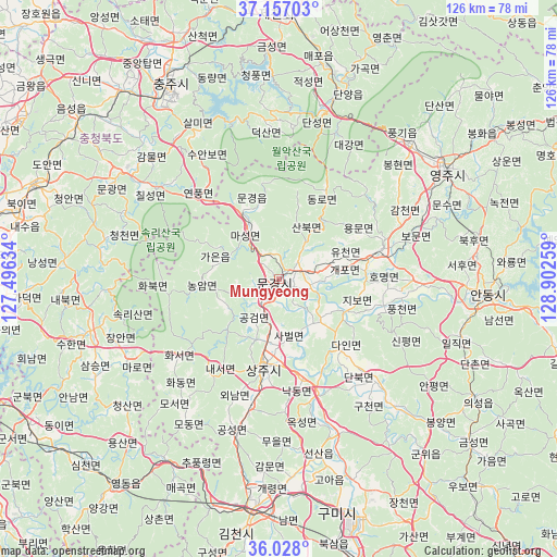
Mungyeong GPS coordinates[2]
36° 35' 40.488" North, 128° 11' 58.056" East
| Map corner | latitude | longitude |
|---|---|---|
| Upper-left | 37.15703°, | 127.49634° |
| Center: | 36.59458°, | 128.19946° |
| Lower-right: | 36.028°, | 128.90259° |
| Map W x H: | 125.5×125.5 km | = 78×78mi |
| max Lat: | 38.37881° ⇑31.8% North |
| Mungyeong: | 36.59458° |
| min Lat: | ⇓68.2% South 33.25333° |
| min Long | Mungyeong | max Long |
| 126.10863° | 128.19946° | 129.55377° |
| W 81.5%⇐ | ⇒18.5% E |
Elevation
Elevation of Mungyeong is 78 m = 256 ft, and this is 7.6 m = 25 ft above average elevation for this country.
| Max E: |
691 m = 2267 ft | 30.8% |
| Mungyeong | 78 m 256 ft | |
| Avg. | 70.4 m = 231 ft | |
Min E: |
1 m = 3 ft | 69.2% |
See also: Mungyeong elevation on elevation.city.
Geographical zone
Mungyeong is located in North temperate zone (between Tropic of Cancer and the Arctic Circle). Distance of this Northern Tropic circle is 1463 km =909.1 mi to South.| Distance of | km | miles | from Mungyeong |
|---|---|---|---|
| North Pole | 5938.1 | 3689.8 | to North |
| Arctic Circle | 3332.2 | 2070.5 | to North |
| Tropic Cancer | 1463 | 909.1 | to South |
| Equator | 4068.9 | 2528.3 | to South |


Nearby cities:
15 places around Mungyeong: (largest is in red/bold)
• Andong
46.8 km =29.1 mi,  93°
93°
• Cheongsan
45.6 km =28.3 mi,  232°
232°
• Cheongseong
49.3 km =30.6 mi, 232°
• Chupungnyeong
45.9 km =28.5 mi,  203°
203°
• Eisen
46 km =28.6 mi,  56°
56°
• Hwanam
30.8 km =19.1 mi,  238°
238°
• Hwanggan
48 km =29.8 mi,  212°
212°
• Jenzan
40.3 km =25 mi,  167°
167°
• Koesan
43.4 km =27 mi,  303°
303°
• Kunwi
52.1 km =32.4 mi,  140°
140°
• Mungyeong
17.6 km =10.9 mi,  332°
332°
• Samseung
47.2 km =29.3 mi, 242°
• Sangju
20.2 km =12.6 mi,  189°
189°
• Yecheon
23.9 km =14.9 mi,  72°
72°
• Yongsan
49.8 km =30.9 mi,  221°
221°
Sources, notices
• [Note1] Compared only with cities in South Korea existing in our database
• [Src1] Map data: © OpenStreetMap contributors (CC-BY-SA)
• [Src2] Other city data from geonames.org with taken over terms of usage.
• [Src3] Geographical zone / Annual Mean Temperature by Robert A. Rohde @ Wikipedia
