Andong geodata
Andong (Gyeongsangbuk-do) is a seat of a first-order administrative division; located in South Korea in Asia/Seoul (GMT+9) time zone. With population of 129,319 people, there are 45 cities with bigger population in this country. Compared to other cities in South Korea, 67.5% of cities are located further ↓South; 89.5% of cities are located further ←West and 78.7% of cities have lower elevation than Andong. Note1


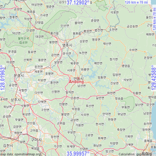
Andong GPS coordinates[2]
36° 33' 58.896" North, 128° 43' 21.9" East
| Map corner | latitude | longitude |
|---|---|---|
| Upper-left | 37.12902°, | 128.01963° |
| Center: | 36.56636°, | 128.72275° |
| Lower-right: | 35.99957°, | 129.42588° |
| Map W x H: | 125.6×125.6 km | = 78×78mi |
| max Lat: | 38.37881° ⇑32.5% North |
| Andong: | 36.56636° |
| min Lat: | ⇓67.5% South 33.25333° |
| min Long | Andong | max Long |
| 126.10863° | 128.72275° | 129.55377° |
| W 89.5%⇐ | ⇒10.5% E |
Elevation
Elevation of Andong is 103 m = 338 ft, and this is 32.6 m = 107 ft above average elevation for this country.
| Max E: |
691 m = 2267 ft | 21.3% |
| Andong | 103 m 338 ft | |
| Avg. | 70.4 m = 231 ft | |
Min E: |
1 m = 3 ft | 78.7% |
See also: Andong elevation on elevation.city.
Geographical zone
Andong is located in North temperate zone (between Tropic of Cancer and the Arctic Circle). Distance of this Northern Tropic circle is 1459.9 km =907.1 mi to South.| Distance of | km | miles | from Andong |
|---|---|---|---|
| North Pole | 5941.3 | 3691.8 | to North |
| Arctic Circle | 3335.4 | 2072.5 | to North |
| Tropic Cancer | 1459.9 | 907.1 | to South |
| Equator | 4065.8 | 2526.4 | to South |


Nearby cities:
15 places around Andong: (largest is in red/bold)
• Cheongha
68.7 km =42.7 mi,  126°
126°
• Cheongsong gun
33.3 km =20.7 mi,  116°
116°
• Eisen
29.5 km =18.3 mi,  343°
343°
• Eisen
69.2 km =43 mi,  164°
164°
• Gumi
61.1 km =38 mi,  214°
214°
• Jenzan
52.5 km =32.6 mi,  226°
226°
• Kunwi
39.2 km =24.4 mi,  200°
200°
• Mungyeong
46.8 km =29.1 mi,  273°
273°
• Mungyeong
57.9 km =36 mi,  288°
288°
• Sangju
53 km =32.9 mi,  251°
251°
• Singwang
68.6 km =42.6 mi,  135°
135°
• T’aebaek
71.8 km =44.6 mi,  19°
19°
• Waegwan
70.1 km =43.6 mi, 204°
• Yecheon
25.9 km =16.1 mi, 292°
• Yeongdeok
60.3 km =37.5 mi,  106°
106°
Sources, notices
• [Note1] Compared only with cities in South Korea existing in our database
• [Src1] Map data: © OpenStreetMap contributors (CC-BY-SA)
• [Src2] Other city data from geonames.org with taken over terms of usage.
• [Src3] Geographical zone / Annual Mean Temperature by Robert A. Rohde @ Wikipedia
