Gwangju geodata
Gwangju (Gyeonggi-do) is a populated place; located in South Korea in Asia/Seoul (GMT+9) time zone. With population of 81,780 people, there are 59 cities with bigger population in this country. Compared to other cities in South Korea, 78% of cities are located further ↓South; 50.3% of cities are located further →East and 54.5% of cities have lower elevation than Gwangju. Note1


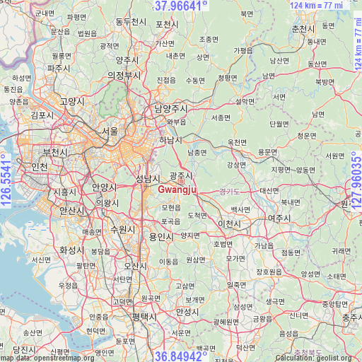
Gwangju GPS coordinates[2]
37° 24' 36" North, 127° 15' 25.992" East
| Map corner | latitude | longitude |
|---|---|---|
| Upper-left | 37.96641°, | 126.5541° |
| Center: | 37.41°, | 127.25722° |
| Lower-right: | 36.84942°, | 127.96035° |
| Map W x H: | 124.2×124.2 km | = 77.2×77.2mi |
| max Lat: | 38.37881° ⇑22% North |
| Gwangju: | 37.41° |
| min Lat: | ⇓78% South 33.25333° |
| min Long | Gwangju | max Long |
| 126.10863° | 127.25722° | 129.55377° |
| W 49.7%⇐ | ⇒50.3% E |
Elevation
Elevation of Gwangju is 48 m = 157 ft, and this is 22.4 m = 73 ft below average elevation for this country.
| Max E: |
691 m = 2267 ft | 45.5% |
| Avg. | 70.4 m = 231 ft | |
| Gwangju | 48 m = 157 ft | |
Min E: |
1 m = 3 ft | 54.5% |
See also: Gwangju elevation on elevation.city.
Geographical zone
Gwangju is located in North temperate zone (between Tropic of Cancer and the Arctic Circle). Distance of this Northern Tropic circle is 1553.7 km =965.4 mi to South.| Distance of | km | miles | from Gwangju |
|---|---|---|---|
| North Pole | 5847.5 | 3633.5 | to North |
| Arctic Circle | 3241.6 | 2014.2 | to North |
| Tropic Cancer | 1553.7 | 965.4 | to South |
| Equator | 4159.6 | 2584.7 | to South |


Nearby cities:
15 places around Gwangju: (largest is in red/bold)
• Anyang-si
29.2 km =18.1 mi,  266°
266°
• Guri-si
23.4 km =14.5 mi,  333°
333°
• Hanam
15.2 km =9.4 mi,  342°
342°
• Hwado
27.3 km =17 mi,  9°
9°
• Icheon-si
21.9 km =13.6 mi,  131°
131°
• Namyangju
25.5 km =15.8 mi,  351°
351°
• Onam
32.4 km =20.1 mi, 351°
• Osan
33.1 km =20.6 mi,  209°
209°
• Pubal
25.8 km =16 mi,  120°
120°
• Seongnam-si
11 km =6.8 mi,  286°
286°
• Seoul
30.1 km =18.7 mi,  305°
305°
• Suwon
25.6 km =15.9 mi,  238°
238°
• Wabu
20.2 km =12.6 mi, 350°
• Yangp'yŏng
22.4 km =13.9 mi,  66°
66°
• Yongsan-dong
28.4 km =17.6 mi,  301°
301°
Sources, notices
• [Note1] Compared only with cities in South Korea existing in our database
• [Src1] Map data: © OpenStreetMap contributors (CC-BY-SA)
• [Src2] Other city data from geonames.org with taken over terms of usage.
• [Src3] Geographical zone / Annual Mean Temperature by Robert A. Rohde @ Wikipedia
