Icheon-si geodata
Icheon-si (Gyeonggi-do) is a populated place; located in South Korea in Asia/Seoul (GMT+9) time zone. With population of 196,230 people, there are 34 cities with bigger population in this country. Compared to other cities in South Korea, 75.2% of cities are located further ↓South; 57.3% of cities are located further ←West and 65.7% of cities have lower elevation than Icheon-si. Note1


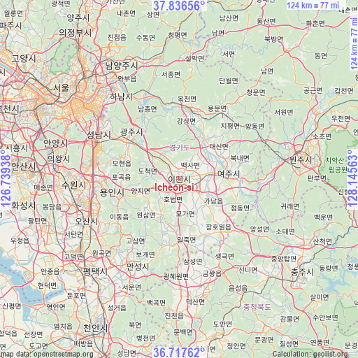
Icheon-si GPS coordinates[2]
37° 16' 45.012" North, 127° 26' 33" East
| Map corner | latitude | longitude |
|---|---|---|
| Upper-left | 37.83656°, | 126.73938° |
| Center: | 37.27917°, | 127.4425° |
| Lower-right: | 36.71762°, | 128.14563° |
| Map W x H: | 124.4×124.4 km | = 77.3×77.3mi |
| max Lat: | 38.37881° ⇑24.8% North |
| Icheon-si: | 37.27917° |
| min Lat: | ⇓75.2% South 33.25333° |
| min Long | Icheon-si | max Long |
| 126.10863° | 127.4425° | 129.55377° |
| W 57.3%⇐ | ⇒42.7% E |
Elevation
Elevation of Icheon-si is 68 m = 223 ft, and this is 2.4 m = 8 ft below average elevation for this country.
| Max E: |
691 m = 2267 ft | 34.3% |
| Avg. | 70.4 m = 231 ft | |
| Icheon-si | 68 m = 223 ft | |
Min E: |
1 m = 3 ft | 65.7% |
See also: Icheon-si elevation on elevation.city.
Geographical zone
Icheon-si is located in North temperate zone (between Tropic of Cancer and the Arctic Circle). Distance of this Northern Tropic circle is 1539.1 km =956.4 mi to South.| Distance of | km | miles | from Icheon-si |
|---|---|---|---|
| North Pole | 5862 | 3642.5 | to North |
| Arctic Circle | 3256.1 | 2023.2 | to North |
| Tropic Cancer | 1539.1 | 956.4 | to South |
| Equator | 4145.1 | 2575.6 | to South |


Nearby cities:
15 places around Icheon-si: (largest is in red/bold)
• Anseong
33.5 km =20.8 mi,  207°
207°
• Chinch'ŏn
47 km =29.2 mi,  179°
179°
• Guri-si
44.5 km =27.7 mi,  323°
323°
• Gwangju
21.9 km =13.6 mi,  311°
311°
• Hanam
35.8 km =22.2 mi, 324°
• Hwado
43.2 km =26.8 mi,  343°
343°
• Namyangju
44.6 km =27.7 mi,  333°
333°
• Osan
35.8 km =22.2 mi,  246°
246°
• Pubal
5.9 km =3.7 mi,  76°
76°
• Seongnam-si
32.2 km =20 mi,  303°
303°
• Suwon
38.4 km =23.9 mi,  271°
271°
• Wabu
39.7 km =24.7 mi, 330°
• Wŏnju
45.2 km =28.1 mi, 79°
• Yangp'yŏng
23.8 km =14.8 mi,  10°
10°
• Yeoju
17 km =10.6 mi, 83°
Sources, notices
• [Note1] Compared only with cities in South Korea existing in our database
• [Src1] Map data: © OpenStreetMap contributors (CC-BY-SA)
• [Src2] Other city data from geonames.org with taken over terms of usage.
• [Src3] Geographical zone / Annual Mean Temperature by Robert A. Rohde @ Wikipedia
