Hwado geodata
Hwado (Gyeonggi-do) is a populated place; located in South Korea in Asia/Seoul (GMT+9) time zone. With population of 106,358 people, there are 46 cities with bigger population in this country. Compared to other cities in South Korea, 83.6% of cities are located further ↓South; 52.1% of cities are located further ←West and 72.7% of cities have lower elevation than Hwado. Note1


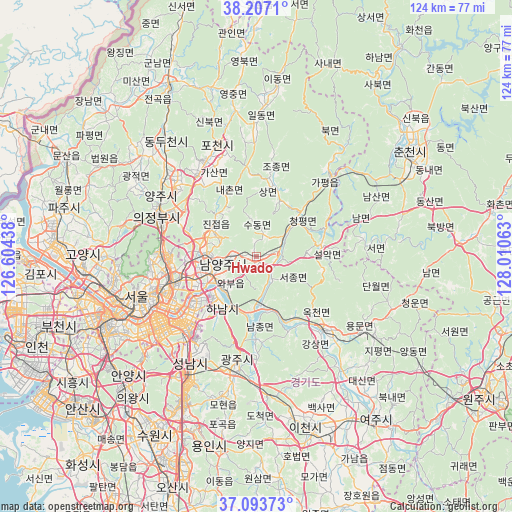
Hwado GPS coordinates[2]
37° 39' 9" North, 127° 18' 27" East
| Map corner | latitude | longitude |
|---|---|---|
| Upper-left | 38.2071°, | 126.60438° |
| Center: | 37.6525°, | 127.3075° |
| Lower-right: | 37.09373°, | 128.01063° |
| Map W x H: | 123.8×123.8 km | = 76.9×76.9mi |
| max Lat: | 38.37881° ⇑16.4% North |
| Hwado: | 37.6525° |
| min Lat: | ⇓83.6% South 33.25333° |
| min Long | Hwado | max Long |
| 126.10863° | 127.3075° | 129.55377° |
| W 52.1%⇐ | ⇒47.9% E |
Elevation
Elevation of Hwado is 86 m = 282 ft, and this is 15.6 m = 51 ft above average elevation for this country.
| Max E: |
691 m = 2267 ft | 27.3% |
| Hwado | 86 m 282 ft | |
| Avg. | 70.4 m = 231 ft | |
Min E: |
1 m = 3 ft | 72.7% |
See also: Hwado elevation on elevation.city.
Geographical zone
Hwado is located in North temperate zone (between Tropic of Cancer and the Arctic Circle). Distance of this Northern Tropic circle is 1580.6 km =982.1 mi to South.| Distance of | km | miles | from Hwado |
|---|---|---|---|
| North Pole | 5820.5 | 3616.7 | to North |
| Arctic Circle | 3214.6 | 1997.5 | to North |
| Tropic Cancer | 1580.6 | 982.1 | to South |
| Equator | 4186.6 | 2601.4 | to South |


Nearby cities:
15 places around Hwado: (largest is in red/bold)
• Cheongpyeong
13.4 km =8.3 mi,  46°
46°
• Gapyeong
26.7 km =16.6 mi,  41°
41°
• Guri-si
16 km =9.9 mi,  247°
247°
• Gwangju
27.3 km =17 mi,  189°
189°
• Hanam
15.4 km =9.6 mi,  215°
215°
• Jinjeop
13.3 km =8.3 mi,  308°
308°
• Namyangju
8.4 km =5.2 mi,  257°
257°
• Onam
10.3 km =6.4 mi,  299°
299°
• Seongnam-si
28.1 km =17.5 mi,  212°
212°
• Seoul
30.5 km =19 mi, 251°
• Su-dong
5.9 km =3.7 mi,  15°
15°
• Uijeongbu-si
24.9 km =15.5 mi,  293°
293°
• Wabu
10.4 km =6.5 mi,  227°
227°
• Yangju
29.5 km =18.3 mi, 312°
• Yangp'yŏng
24.2 km =15 mi,  138°
138°
Sources, notices
• [Note1] Compared only with cities in South Korea existing in our database
• [Src1] Map data: © OpenStreetMap contributors (CC-BY-SA)
• [Src2] Other city data from geonames.org with taken over terms of usage.
• [Src3] Geographical zone / Annual Mean Temperature by Robert A. Rohde @ Wikipedia
