Asan geodata
Asan (Chungcheongnam-do) is a populated place; located in South Korea in Asia/Seoul (GMT+9) time zone. With population of 97,749 people, there are 48 cities with bigger population in this country. Compared to other cities in South Korea, 70.6% of cities are located further ↓South; 65.4% of cities are located further →East and 64.7% of cities have higher elevation than Asan. Note1


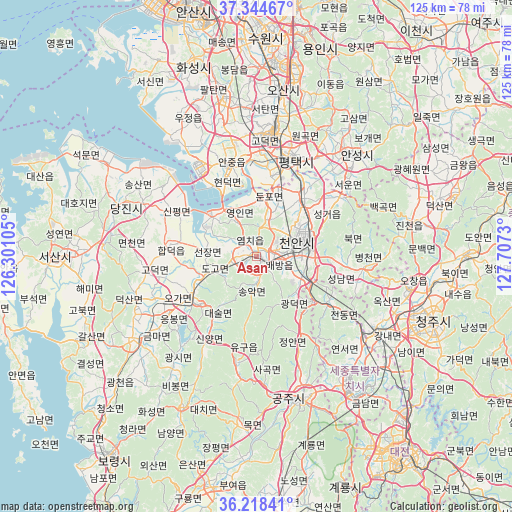
Asan GPS coordinates[2]
36° 47' 0.996" North, 127° 0' 15.012" East
| Map corner | latitude | longitude |
|---|---|---|
| Upper-left | 37.34467°, | 126.30105° |
| Center: | 36.78361°, | 127.00417° |
| Lower-right: | 36.21841°, | 127.7073° |
| Map W x H: | 125.2×125.2 km | = 77.8×77.8mi |
| max Lat: | 38.37881° ⇑29.4% North |
| Asan: | 36.78361° |
| min Lat: | ⇓70.6% South 33.25333° |
| min Long | Asan | max Long |
| 126.10863° | 127.00417° | 129.55377° |
| W 34.6%⇐ | ⇒65.4% E |
Elevation
Elevation of Asan is 27 m = 89 ft, and this is 43.4 m = 142 ft below average elevation for this country.
| Max E: |
691 m = 2267 ft | 64.7% |
| Avg. | 70.4 m = 231 ft | |
| Asan | 27 m = 89 ft | |
Min E: |
1 m = 3 ft | 35.3% |
See also: Asan elevation on elevation.city.
Geographical zone
Asan is located in North temperate zone (between Tropic of Cancer and the Arctic Circle). Distance of this Northern Tropic circle is 1484 km =922.1 mi to South.| Distance of | km | miles | from Asan |
|---|---|---|---|
| North Pole | 5917.1 | 3676.7 | to North |
| Arctic Circle | 3311.2 | 2057.5 | to North |
| Tropic Cancer | 1484 | 922.1 | to South |
| Equator | 4090 | 2541.4 | to South |


Nearby cities:
15 places around Asan: (largest is in red/bold)
• Anseong
34.6 km =21.5 mi,  43°
43°
• Cheonan
13.4 km =8.3 mi,  79°
79°
• Cheongju-si
46.2 km =28.7 mi,  110°
110°
• Cheongnam
48.1 km =29.9 mi,  185°
185°
• Cheongyang
41 km =25.5 mi,  205°
205°
• Chinch'ŏn
39.9 km =24.8 mi, 78°
• Gongju
38 km =23.6 mi,  163°
163°
• Hongseong
36.4 km =22.6 mi,  236°
236°
• Hwaseong-si
49.9 km =31 mi,  340°
340°
• Osan
41.4 km =25.7 mi,  8°
8°
• Sejong
33.3 km =20.7 mi,  129°
129°
• Seonghwan
18.5 km =11.5 mi, 37°
• Seosan
49.2 km =30.6 mi,  269°
269°
• Tangjin
35.5 km =22.1 mi,  290°
290°
• Yesan
18.6 km =11.6 mi,  230°
230°
Sources, notices
• [Note1] Compared only with cities in South Korea existing in our database
• [Src1] Map data: © OpenStreetMap contributors (CC-BY-SA)
• [Src2] Other city data from geonames.org with taken over terms of usage.
• [Src3] Geographical zone / Annual Mean Temperature by Robert A. Rohde @ Wikipedia
