Nur-Sultan geodata
Nur-Sultan is a capital of a political entity; located in Kazakhstan in Asia/Almaty (GMT+5) time zone. With population of 345,604 people, there are 4 cities with bigger population in this country. Compared to other cities in Kazakhstan, 76.3% of cities are located further ↓South; 54.4% of cities are located further ←West and 54.1% of cities have lower elevation than Nur-Sultan. Note1


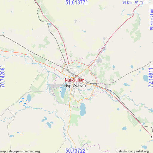
Nur-Sultan GPS coordinates[2]
51° 10' 48.36" North, 71° 26' 45.528" East
| Map corner | latitude | longitude |
|---|---|---|
| Upper-left | 51.61877°, | 70.74286° |
| Center: | 51.1801°, | 71.44598° |
| Lower-right: | 50.73722°, | 72.14911° |
| Map W x H: | 98×98 km | = 60.9×60.9mi |
| max Lat: | 54.90596° ⇑23.7% North |
| Nur-Sultan: | 51.1801° |
| min Lat: | ⇓76.3% South 40.66338° |
| min Long | Nur-Sultan | max Long |
| 46.83361° | 71.44598° | 84.87144° |
| W 54.4%⇐ | ⇒45.6% E |
Elevation
Elevation of Nur-Sultan is 358 m = 1175 ft, and this is 1.5 m = 5 ft above average elevation for this country.
| Max E: |
1847 m = 6060 ft | 45.9% |
| Nur-Sultan | 358 m 1175 ft | |
| Avg. | 356.5 m = 1170 ft | |
Min E: |
-26 m = -85 ft | 54.1% |
See also: Nur-Sultan elevation on elevation.city.
Geographical zone
Nur-Sultan is located in North temperate zone (between Tropic of Cancer and the Arctic Circle). Distance of this North polar circle is 1710.5 km =1062.9 mi to North.| Distance of | km | miles | from Nur-Sultan |
|---|---|---|---|
| North Pole | 4316.4 | 2682.1 | to North |
| Arctic Circle | 1710.5 | 1062.9 | to North |
| Tropic Cancer | 3084.8 | 1916.8 | to South |
| Equator | 5690.7 | 3536 | to South |


Nearby cities:
15 places around Nur-Sultan: (largest is in red/bold)
• Akkol
96.8 km =60.1 mi,  339°
339°
• Aksu
144.9 km =90 mi,  14°
14°
• Aktau
155.1 km =96.4 mi,  132°
132°
• Astrakhan
121 km =75.2 mi,  288°
288°
• Egindiköl
138 km =85.7 mi,  264°
264°
• Kyzylzhar
156.4 km =97.2 mi,  148°
148°
• Kīevka
102.3 km =63.6 mi,  175°
175°
• Osakarovka
104.6 km =65 mi, 131°
• Shortandy
65.7 km =40.8 mi,  331°
331°
• Stepnogorsk
133.6 km =83 mi, 12°
• Temirtau
164.7 km =102.3 mi,  139°
139°
• Tokarevka
169.2 km =105.1 mi, 134°
• Yermentau
125 km =77.7 mi,  66°
66°
• Zavodskoy
148.7 km =92.4 mi,  15°
15°
• Zholymbet
65.2 km =40.5 mi, 16°
Sources, notices
• [Note1] Compared only with cities in Kazakhstan existing in our database
• [Src1] Map data: © OpenStreetMap contributors (CC-BY-SA)
• [Src2] Other city data from geonames.org with taken over terms of usage.
• [Src3] Geographical zone / Annual Mean Temperature by Robert A. Rohde @ Wikipedia
