Luang Namtha geodata
Luang Namtha (Loungnamtha) is a seat of a first-order administrative division; located in Laos in Asia/Vientiane (GMT+7) time zone. With population of 3,225 people, there are 22 cities with bigger population in this country. Compared to other cities in Laos, 90.4% of cities are located further ↓South; 90.4% of cities are located further →East and 71.2% of cities have lower elevation than Luang Namtha. Note1


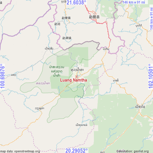
Luang Namtha GPS coordinates[2]
20° 56' 54.96" North, 101° 24' 6.768" East
| Map corner | latitude | longitude |
|---|---|---|
| Upper-left | 21.6038°, | 100.69876° |
| Center: | 20.9486°, | 101.40188° |
| Lower-right: | 20.29052°, | 102.10501° |
| Map W x H: | 146×146 km | = 90.7×90.7mi |
| max Lat: | 21.6808° ⇑9.6% North |
| Luang Namtha: | 20.9486° |
| min Lat: | ⇓90.4% South 14.11785° |
| min Long | Luang Namtha | max Long |
| 100.4178° | 101.40188° | 107.26667° |
| W 9.6%⇐ | ⇒90.4% E |
Elevation
Elevation of Luang Namtha is 551 m = 1808 ft, and this is 77.4 m = 254 ft above average elevation for this country.
| Max E: |
1722 m = 5650 ft | 28.8% |
| Luang Namtha | 551 m 1808 ft | |
| Avg. | 473.6 m = 1554 ft | |
Min E: |
83 m = 272 ft | 71.2% |
See also: Laos elevation on elevation.city.
Geographical zone
Luang Namtha is located in North Torrid zone (between Equator and Tropic of Cancer). Distance of this Northern Tropic circle is 276.7 km =171.9 mi to North.| Distance of | km | miles | from Luang Namtha |
|---|---|---|---|
| North Pole | 7677.8 | 4770.8 | to North |
| Arctic Circle | 5071.9 | 3151.5 | to North |
| Tropic Cancer | 276.7 | 171.9 | to North |
| Equator | 2329.3 | 1447.4 | to South |


Nearby cities:
15 places around Luang Namtha: (largest is in red/bold)
• Ban Houakhoua
125.8 km =78.2 mi,  231°
231°
• Ban Houayxay
127.2 km =79 mi, 233°
• Ban Namnga
139.6 km =86.7 mi,  79°
79°
• Ban Pakla
74.2 km =46.1 mi,  96°
96°
• Ban Xiang-Ngeun
155.3 km =96.5 mi,  148°
148°
• Khoa
115.5 km =71.8 mi, 82°
• Luang Prabang
140.7 km =87.4 mi, 147°
• Muang Kasi
210.8 km =131 mi,  155°
155°
• Muang Long
60.4 km =37.5 mi,  271°
271°
• Muang Nalè
46.5 km =28.9 mi,  174°
174°
• Muang Sing
37.8 km =23.5 mi,  315°
315°
• Muang Xay
66.8 km =41.5 mi,  115°
115°
• Phôngsali
108.9 km =67.7 mi,  41°
41°
• Sainyabuli
190.8 km =118.6 mi, 170°
• Viengthong
219.9 km =136.6 mi,  108°
108°
Sources, notices
• [Note1] Compared only with cities in Laos existing in our database
• [Src1] Map data: © OpenStreetMap contributors (CC-BY-SA)
• [Src2] Other city data from geonames.org with taken over terms of usage.
• [Src3] Geographical zone / Annual Mean Temperature by Robert A. Rohde @ Wikipedia
