Phôngsali geodata
Phôngsali is a seat of a first-order administrative division; located in Laos in Asia/Vientiane (GMT+7) time zone. With population of 13,500 people, there are 12 cities with bigger population in this country. Compared to other cities in Laos, 100% of cities are located further ↓South; 80.8% of cities are located further →East and 96.2% of cities have lower elevation than Phôngsali. Note1


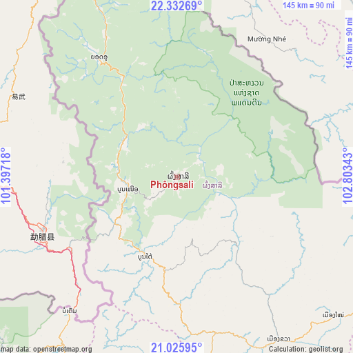
Phôngsali GPS coordinates[2]
21° 40' 50.88" North, 102° 6' 1.08" East
| Map corner | latitude | longitude |
|---|---|---|
| Upper-left | 22.33269°, | 101.39718° |
| Center: | 21.6808°, | 102.1003° |
| Lower-right: | 21.02595°, | 102.80343° |
| Map W x H: | 145.3×145.3 km | = 90.3×90.3mi |
| max Lat: | 21.6808° ⇑0% North |
| Phôngsali: | 21.6808° |
| min Lat: | ⇓100% South 14.11785° |
| min Long | Phôngsali | max Long |
| 100.4178° | 102.1003° | 107.26667° |
| W 19.2%⇐ | ⇒80.8% E |
Elevation
Elevation of Phôngsali is 1344 m = 4409 ft, and this is 870.4 m = 2856 ft above average elevation for this country.
| Max E: |
1722 m = 5650 ft | 3.8% |
| Phôngsali | 1344 m 4409 ft | |
| Avg. | 473.6 m = 1554 ft | |
Min E: |
83 m = 272 ft | 96.2% |
See also: Laos elevation on elevation.city.
Geographical zone
Phôngsali is located in North Torrid zone (between Equator and Tropic of Cancer). Distance of this Northern Tropic circle is 195.2 km =121.3 mi to North.| Distance of | km | miles | from Phôngsali |
|---|---|---|---|
| North Pole | 7596.4 | 4720.2 | to North |
| Arctic Circle | 4990.5 | 3101 | to North |
| Tropic Cancer | 195.2 | 121.3 | to North |
| Equator | 2410.7 | 1497.9 | to South |


Nearby cities:
15 places around Phôngsali: (largest is in red/bold)
• Ban Houakhoua
233.8 km =145.3 mi,  226°
226°
• Ban Houayxay
234.8 km =145.9 mi, 228°
• Ban Namnga
86 km =53.4 mi,  131°
131°
• Ban Pakla
90.2 km =56 mi,  179°
179°
• Ban Xiang-Ngeun
213.9 km =132.9 mi, 177°
• Huameung
249.7 km =155.2 mi, 132°
• Khoa
79.1 km =49.2 mi,  147°
147°
• Luang Namtha
108.9 km =67.7 mi,  221°
221°
• Luang Prabang
199.6 km =124 mi, 178°
• Muang Long
154.6 km =96.1 mi,  239°
239°
• Muang Nalè
144.6 km =89.9 mi,  207°
207°
• Muang Sing
112.6 km =70 mi, 241°
• Muang Xay
110.6 km =68.7 mi,  186°
186°
• Viengthong
202.7 km =126 mi,  137°
137°
• Xam Nua
245.9 km =152.8 mi,  124°
124°
Sources, notices
• [Note1] Compared only with cities in Laos existing in our database
• [Src1] Map data: © OpenStreetMap contributors (CC-BY-SA)
• [Src2] Other city data from geonames.org with taken over terms of usage.
• [Src3] Geographical zone / Annual Mean Temperature by Robert A. Rohde @ Wikipedia
