Khoa geodata
Khoa (Phôngsali) is a seat of a second-order administrative division; located in Laos in Asia/Vientiane (GMT+7) time zone. In our database, there are 24 cities with bigger population. Compared to other cities in Laos, 94.2% of cities are located further ↓South; 67.3% of cities are located further →East and 55.8% of cities have lower elevation than Khoa. Note1


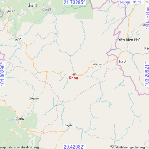
Khoa GPS coordinates[2]
21° 4' 41.988" North, 102° 30' 21.888" East
| Map corner | latitude | longitude |
|---|---|---|
| Upper-left | 21.73295°, | 101.80296° |
| Center: | 21.07833°, | 102.50608° |
| Lower-right: | 20.42082°, | 103.20921° |
| Map W x H: | 145.9×145.9 km | = 90.7×90.7mi |
| max Lat: | 21.6808° ⇑5.8% North |
| Khoa: | 21.07833° |
| min Lat: | ⇓94.2% South 14.11785° |
| min Long | Khoa | max Long |
| 100.4178° | 102.50608° | 107.26667° |
| W 32.7%⇐ | ⇒67.3% E |
Elevation
Elevation of Khoa is 394 m = 1293 ft, and this is 79.6 m = 261 ft below average elevation for this country.
| Max E: |
1722 m = 5650 ft | 44.2% |
| Avg. | 473.6 m = 1554 ft | |
| Khoa | 394 m = 1293 ft | |
Min E: |
83 m = 272 ft | 55.8% |
See also: Laos elevation on elevation.city.
Geographical zone
Khoa is located in North Torrid zone (between Equator and Tropic of Cancer). Distance of this Northern Tropic circle is 262.2 km =162.9 mi to North.| Distance of | km | miles | from Khoa |
|---|---|---|---|
| North Pole | 7663.4 | 4761.8 | to North |
| Arctic Circle | 5057.5 | 3142.6 | to North |
| Tropic Cancer | 262.2 | 162.9 | to North |
| Equator | 2343.7 | 1456.3 | to South |


Nearby cities:
15 places around Khoa: (largest is in red/bold)
• Ban Namnga
25 km =15.5 mi,  65°
65°
• Ban Pakla
47.1 km =29.3 mi,  240°
240°
• Ban Xiang-Ngeun
150.6 km =93.6 mi,  192°
192°
• Huameung
174.6 km =108.5 mi,  126°
126°
• Luang Namtha
115.5 km =71.8 mi,  262°
262°
• Luang Prabang
138.1 km =85.8 mi,  196°
196°
• Muang Long
175.4 km =109 mi,  265°
265°
• Muang Nalè
125.7 km =78.1 mi, 241°
• Muang Phônsavan
194.7 km =121 mi,  158°
158°
• Muang Sing
141.4 km =87.9 mi,  275°
275°
• Muang Xay
69.2 km =43 mi,  231°
231°
• Phôngsali
79.1 km =49.2 mi,  327°
327°
• Viangxai
193.6 km =120.3 mi,  112°
112°
• Viengthong
125.6 km =78 mi, 131°
• Xam Nua
176.1 km =109.4 mi, 114°
Sources, notices
• [Note1] Compared only with cities in Laos existing in our database
• [Src1] Map data: © OpenStreetMap contributors (CC-BY-SA)
• [Src2] Other city data from geonames.org with taken over terms of usage.
• [Src3] Geographical zone / Annual Mean Temperature by Robert A. Rohde @ Wikipedia
