Jbaïl geodata
Jbaïl (Mont-Liban) is a seat of a second-order administrative division; located in Lebanon in Asia/Beirut (GMT+3) time zone. With population of 20,784 people, there are 11 cities with bigger population in this country. Compared to other cities in Lebanon, 75% of cities are located further ↓South; 50% of cities are located further ←West and 87.5% of cities have higher elevation than Jbaïl. Note1


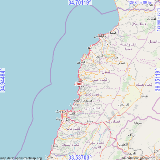
Jbaïl GPS coordinates[2]
34° 7' 15.996" North, 35° 38' 53.016" East
| Map corner | latitude | longitude |
|---|---|---|
| Upper-left | 34.70119°, | 34.94494° |
| Center: | 34.12111°, | 35.64806° |
| Lower-right: | 33.53703°, | 36.35119° |
| Map W x H: | 129.4×129.4 km | = 80.4×80.4mi |
| max Lat: | 34.54278° ⇑25% North |
| Jbaïl: | 34.12111° |
| min Lat: | ⇓75% South 33.11023° |
| min Long | Jbaïl | max Long |
| 35.13972° | 35.64806° | 36.38472° |
| W 50%⇐ | ⇒50% E |
Elevation
Elevation of Jbaïl is 33 m = 108 ft, and this is 522.2 m = 1713 ft below average elevation for this country.
| Max E: |
1442 m = 4731 ft | 87.5% |
| Avg. | 555.2 m = 1822 ft | |
| Jbaïl | 33 m = 108 ft | |
Min E: |
7 m = 23 ft | 12.5% |
See also: Lebanon elevation on elevation.city.
Geographical zone
Jbaïl is located in North temperate zone (between Tropic of Cancer and the Arctic Circle). Distance of this Northern Tropic circle is 1188 km =738.2 mi to South.| Distance of | km | miles | from Jbaïl |
|---|---|---|---|
| North Pole | 6213.2 | 3860.7 | to North |
| Arctic Circle | 3607.3 | 2241.5 | to North |
| Tropic Cancer | 1188 | 738.2 | to South |
| Equator | 3793.9 | 2357.4 | to South |


Nearby cities:
15 places around Jbaïl: (largest is in red/bold)
• Aaley
35.4 km =22 mi,  187°
187°
• Amioûn
24.8 km =15.4 mi,  36°
36°
• Baabda
33.3 km =20.7 mi,  196°
196°
• Batroûn
14.9 km =9.3 mi,  3°
3°
• Bcharré
36.3 km =22.6 mi,  66°
66°
• Beirut
28.7 km =17.8 mi,  208°
208°
• Bhamdoun
36.3 km =22.6 mi,  179°
179°
• Bhamdoûn el Mhatta
34.8 km =21.6 mi, 178°
• Jdaidet el Matn
26.7 km =16.6 mi, 196°
• Jounieh
15.8 km =9.8 mi, 190°
• Ra’s Bayrūt
28.9 km =18 mi, 211°
• Sîr ed Danniyé
45.8 km =28.5 mi,  50°
50°
• Tripoli
39.1 km =24.3 mi,  27°
27°
• Zahlé
38.5 km =23.9 mi,  142°
142°
• Zghartā
38.2 km =23.7 mi, 36°
In other languages:
- In Spanish: Biblos
- In France: Byblos
- In German: Byblos
- In Italian: Biblo
- In Russian: Библ (Bibl)
Sources, notices
• [Note1] Compared only with cities in Lebanon existing in our database
• [Src1] Map data: © OpenStreetMap contributors (CC-BY-SA)
• [Src2] Other city data from geonames.org with taken over terms of usage.
• [Src3] Geographical zone / Annual Mean Temperature by Robert A. Rohde @ Wikipedia
