Aaley geodata
Aaley (Mont-Liban) is a seat of a second-order administrative division; located in Lebanon in Asia/Beirut (GMT+3) time zone. In our database, there are 19 cities with bigger population. Compared to other cities in Lebanon, 53.1% of cities are located further ↑North; 56.2% of cities are located further →East and 68.8% of cities have lower elevation than Aaley. Note1


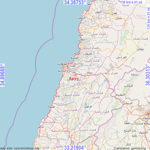
Aaley GPS coordinates[2]
33° 48' 19.008" North, 35° 36' 0" East
| Map corner | latitude | longitude |
|---|---|---|
| Upper-left | 34.38753°, | 34.89688° |
| Center: | 33.80528°, | 35.6° |
| Lower-right: | 33.21904°, | 36.30313° |
| Map W x H: | 129.9×129.9 km | = 80.7×80.7mi |
| max Lat: | 34.54278° ⇑53.1% North |
| Aaley: | 33.80528° |
| min Lat: | ⇓46.9% South 33.11023° |
| min Long | Aaley | max Long |
| 35.13972° | 35.6° | 36.38472° |
| W 43.8%⇐ | ⇒56.2% E |
Elevation
Elevation of Aaley is 878 m = 2881 ft, and this is 322.8 m = 1059 ft above average elevation for this country.
| Max E: |
1442 m = 4731 ft | 31.2% |
| Aaley | 878 m 2881 ft | |
| Avg. | 555.2 m = 1822 ft | |
Min E: |
7 m = 23 ft | 68.8% |
See also: Lebanon elevation on elevation.city.
Geographical zone
Aaley is located in North temperate zone (between Tropic of Cancer and the Arctic Circle). Distance of this Northern Tropic circle is 1152.9 km =716.4 mi to South.| Distance of | km | miles | from Aaley |
|---|---|---|---|
| North Pole | 6248.3 | 3882.5 | to North |
| Arctic Circle | 3642.4 | 2263.3 | to North |
| Tropic Cancer | 1152.9 | 716.4 | to South |
| Equator | 3758.8 | 2335.6 | to South |


Nearby cities:
15 places around Aaley: (largest is in red/bold)
• Aanjar
31.8 km =19.8 mi,  105°
105°
• Baabda
6.1 km =3.8 mi,  301°
301°
• Beirut
13.4 km =8.3 mi,  317°
317°
• Beït ed Dîne
12.5 km =7.8 mi,  188°
188°
• Bhamdoun
4.9 km =3 mi,  103°
103°
• Bhamdoûn el Mhatta
5.5 km =3.4 mi,  86°
86°
• Jbaïl
35.4 km =22 mi,  7°
7°
• Jdaidet el Matn
10 km =6.2 mi,  341°
341°
• Jezzîne
29.3 km =18.2 mi,  182°
182°
• Joubb Jannîne
26.1 km =16.2 mi,  139°
139°
• Jounieh
19.6 km =12.2 mi,  4°
4°
• Ra’s Bayrūt
15.1 km =9.4 mi,  314°
314°
• Râchaïya el Ouadi
40.7 km =25.3 mi,  146°
146°
• Sidon
34.7 km =21.6 mi,  217°
217°
• Zahlé
28.3 km =17.6 mi,  80°
80°
Sources, notices
• [Note1] Compared only with cities in Lebanon existing in our database
• [Src1] Map data: © OpenStreetMap contributors (CC-BY-SA)
• [Src2] Other city data from geonames.org with taken over terms of usage.
• [Src3] Geographical zone / Annual Mean Temperature by Robert A. Rohde @ Wikipedia
