Beirut geodata
Beirut (Beyrouth) is a capital of a political entity; located in Lebanon in Asia/Beirut (GMT+3) time zone. With population of 1,916,100 people, there are 0 cities with bigger population in this country. Compared to other cities in Lebanon, 62.5% of cities are located further ↓South; 75% of cities are located further →East and 81.2% of cities have higher elevation than Beirut. Note1


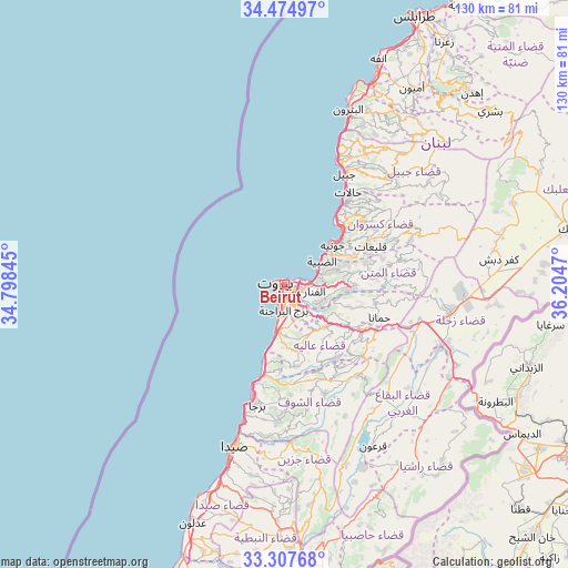
Beirut GPS coordinates[2]
33° 53' 35.952" North, 35° 30' 5.652" East
| Map corner | latitude | longitude |
|---|---|---|
| Upper-left | 34.47497°, | 34.79845° |
| Center: | 33.89332°, | 35.50157° |
| Lower-right: | 33.30768°, | 36.2047° |
| Map W x H: | 129.8×129.8 km | = 80.7×80.7mi |
| max Lat: | 34.54278° ⇑37.5% North |
| Beirut: | 33.89332° |
| min Lat: | ⇓62.5% South 33.11023° |
| min Long | Beirut | max Long |
| 35.13972° | 35.50157° | 36.38472° |
| W 25%⇐ | ⇒75% E |
Elevation
Elevation of Beirut is 40 m = 131 ft, and this is 515.2 m = 1690 ft below average elevation for this country.
| Max E: |
1442 m = 4731 ft | 81.2% |
| Avg. | 555.2 m = 1822 ft | |
| Beirut | 40 m = 131 ft | |
Min E: |
7 m = 23 ft | 18.8% |
See also: Beirut elevation on elevation.city.
Geographical zone
Beirut is located in North temperate zone (between Tropic of Cancer and the Arctic Circle). Distance of this Northern Tropic circle is 1162.7 km =722.5 mi to South.| Distance of | km | miles | from Beirut |
|---|---|---|---|
| North Pole | 6238.5 | 3876.4 | to North |
| Arctic Circle | 3632.6 | 2257.2 | to North |
| Tropic Cancer | 1162.7 | 722.5 | to South |
| Equator | 3768.6 | 2341.7 | to South |


Nearby cities:
15 places around Beirut: (largest is in red/bold)
• Aaley
13.4 km =8.3 mi,  137°
137°
• Aanjar
43.7 km =27.2 mi,  114°
114°
• Baabda
7.7 km =4.8 mi,  149°
149°
• Batroûn
42.7 km =26.5 mi,  19°
19°
• Beït ed Dîne
23.3 km =14.5 mi,  161°
161°
• Bhamdoun
17.6 km =10.9 mi,  128°
128°
• Bhamdoûn el Mhatta
17.4 km =10.8 mi,  122°
122°
• Jbaïl
28.7 km =17.8 mi,  28°
28°
• Jdaidet el Matn
6 km =3.7 mi,  92°
92°
• Jezzîne
39.8 km =24.7 mi,  168°
168°
• Joubb Jannîne
39.5 km =24.5 mi, 138°
• Jounieh
14.5 km =9 mi,  47°
47°
• Ra’s Bayrūt
1.8 km =1.1 mi,  293°
293°
• Sidon
39.2 km =24.4 mi,  197°
197°
• Zahlé
37.3 km =23.2 mi,  97°
97°
Sources, notices
• [Note1] Compared only with cities in Lebanon existing in our database
• [Src1] Map data: © OpenStreetMap contributors (CC-BY-SA)
• [Src2] Other city data from geonames.org with taken over terms of usage.
• [Src3] Geographical zone / Annual Mean Temperature by Robert A. Rohde @ Wikipedia
