Baalbek geodata
Baalbek (Baalbek-Hermel) is a seat of a first-order administrative division; located in Lebanon in Asia/Beirut (GMT+3) time zone. With population of 30,916 people, there are 9 cities with bigger population in this country. Compared to other cities in Lebanon, 71.9% of cities are located further ↓South; 96.9% of cities are located further ←West and 93.8% of cities have lower elevation than Baalbek. Note1


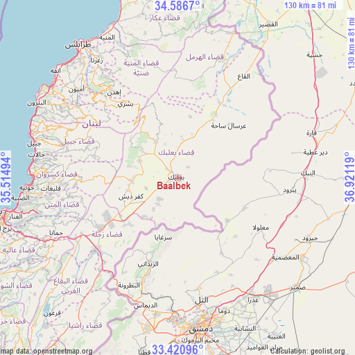
Baalbek GPS coordinates[2]
34° 0' 20.988" North, 36° 13' 5.016" East
| Map corner | latitude | longitude |
|---|---|---|
| Upper-left | 34.5867°, | 35.51494° |
| Center: | 34.00583°, | 36.21806° |
| Lower-right: | 33.42096°, | 36.92119° |
| Map W x H: | 129.6×129.6 km | = 80.5×80.5mi |
| max Lat: | 34.54278° ⇑28.1% North |
| Baalbek: | 34.00583° |
| min Lat: | ⇓71.9% South 33.11023° |
| min Long | Baalbek | max Long |
| 35.13972° | 36.21806° | 36.38472° |
| W 96.9%⇐ | ⇒3.1% E |
Elevation
Elevation of Baalbek is 1183 m = 3881 ft, and this is 627.8 m = 2060 ft above average elevation for this country.
| Max E: |
1442 m = 4731 ft | 6.2% |
| Baalbek | 1183 m 3881 ft | |
| Avg. | 555.2 m = 1822 ft | |
Min E: |
7 m = 23 ft | 93.8% |
See also: Lebanon elevation on elevation.city.
Geographical zone
Baalbek is located in North temperate zone (between Tropic of Cancer and the Arctic Circle). Distance of this Northern Tropic circle is 1175.2 km =730.2 mi to South.| Distance of | km | miles | from Baalbek |
|---|---|---|---|
| North Pole | 6226 | 3868.7 | to North |
| Arctic Circle | 3620.1 | 2249.4 | to North |
| Tropic Cancer | 1175.2 | 730.2 | to South |
| Equator | 3781.1 | 2349.5 | to South |


Nearby cities:
15 places around Baalbek: (largest is in red/bold)
• Aanjar
40.7 km =25.3 mi,  220°
220°
• Amioûn
49.9 km =31 mi,  310°
310°
• Batroûn
58.5 km =36.4 mi,  298°
298°
• Bcharré
33.3 km =20.7 mi,  324°
324°
• Bhamdoun
57.3 km =35.6 mi,  245°
245°
• Bhamdoûn el Mhatta
56 km =34.8 mi, 246°
• El Hermel
45.8 km =28.5 mi,  19°
19°
• Halba
61 km =37.9 mi,  347°
347°
• Jbaïl
54 km =33.6 mi,  283°
283°
• Joubb Jannîne
58.1 km =36.1 mi, 223°
• Jounieh
55.4 km =34.4 mi,  267°
267°
• Sîr ed Danniyé
45.6 km =28.3 mi,  337°
337°
• Tripoli
58.7 km =36.5 mi, 324°
• Zahlé
34.1 km =21.2 mi,  238°
238°
• Zghartā
52.7 km =32.7 mi,  325°
325°
Sources, notices
• [Note1] Compared only with cities in Lebanon existing in our database
• [Src1] Map data: © OpenStreetMap contributors (CC-BY-SA)
• [Src2] Other city data from geonames.org with taken over terms of usage.
• [Src3] Geographical zone / Annual Mean Temperature by Robert A. Rohde @ Wikipedia
