Prienai geodata
Prienai (Kaunas) is a seat of a second-order administrative division; located in Lithuania in Europe/Vilnius (GMT+3) time zone. With population of 11,352 people, there are 46 cities with bigger population in this country. Compared to other cities in Lithuania, 85.8% of cities are located further ↑North; 52.2% of cities are located further ←West and 75.4% of cities have higher elevation than Prienai. Note1


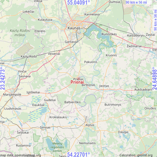
Prienai GPS coordinates[2]
54° 38' 9.6" North, 23° 56' 45.06" East
| Map corner | latitude | longitude |
|---|---|---|
| Upper-left | 55.04091°, | 23.24273° |
| Center: | 54.636°, | 23.94585° |
| Lower-right: | 54.22701°, | 24.64898° |
| Map W x H: | 90.5×90.5 km | = 56.2×56.2mi |
| max Lat: | 56.36149° ⇑85.8% North |
| Prienai: | 54.636° |
| min Lat: | ⇓14.2% South 54.01573° |
| min Long | Prienai | max Long |
| 20.99651° | 23.94585° | 26.43984° |
| W 52.2%⇐ | ⇒47.8% E |
Elevation
Elevation of Prienai is 59 m = 194 ft, and this is 31.7 m = 104 ft below average elevation for this country.
| Max E: |
204 m = 669 ft | 75.4% |
| Avg. | 90.7 m = 298 ft | |
| Prienai | 59 m = 194 ft | |
Min E: |
-1 m = -3 ft | 24.6% |
See also: Lithuania elevation on elevation.city.
Geographical zone
Prienai is located in North temperate zone (between Tropic of Cancer and the Arctic Circle). Distance of this North polar circle is 1326.2 km =824.1 mi to North.| Distance of | km | miles | from Prienai |
|---|---|---|---|
| North Pole | 3932.1 | 2443.3 | to North |
| Arctic Circle | 1326.2 | 824.1 | to North |
| Tropic Cancer | 3469 | 2155.5 | to South |
| Equator | 6075 | 3774.8 | to South |


Nearby cities:
15 places around Prienai: (largest is in red/bold)
• Akademija (Kaunas)
30 km =18.6 mi,  344°
344°
• Aleksotas
27.3 km =17 mi,  354°
354°
• Alytus
27.4 km =17 mi,  166°
166°
• Birštonas
6.5 km =4 mi,  118°
118°
• Dainava (Kaunas)
31.1 km =19.3 mi,  2°
2°
• Eiguliai
32.8 km =20.4 mi,  358°
358°
• Garliava
21.2 km =13.2 mi, 346°
• Jieznas
15.4 km =9.6 mi,  105°
105°
• Kaunas
29.7 km =18.5 mi, 355°
• Kazlų Rūda
31.9 km =19.8 mi,  293°
293°
• Linksmakalnis
13.6 km =8.5 mi, 355°
• Mastaiciai
21.5 km =13.4 mi, 342°
• Noreikiškės
28.7 km =17.8 mi, 347°
• Simnas
34.2 km =21.3 mi,  214°
214°
• Šilainiai
32.8 km =20.4 mi, 353°
Sources, notices
• [Note1] Compared only with cities in Lithuania existing in our database
• [Src1] Map data: © OpenStreetMap contributors (CC-BY-SA)
• [Src2] Other city data from geonames.org with taken over terms of usage.
• [Src3] Geographical zone / Annual Mean Temperature by Robert A. Rohde @ Wikipedia
