Klaipėda geodata
Klaipėda (Klaipėda County) is a seat of a first-order administrative division; located in Lithuania in Europe/Vilnius (GMT+3) time zone. With population of 192,307 people, there are 2 cities with bigger population in this country. Compared to other cities in Lithuania, 72.4% of cities are located further ↓South; 96.3% of cities are located further →East and 94.8% of cities have higher elevation than Klaipėda. Note1


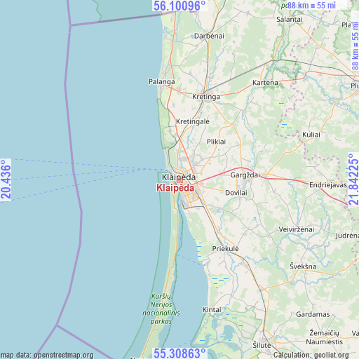
Klaipėda GPS coordinates[2]
55° 42' 24.48" North, 21° 8' 20.832" East
| Map corner | latitude | longitude |
|---|---|---|
| Upper-left | 56.10096°, | 20.436° |
| Center: | 55.7068°, | 21.13912° |
| Lower-right: | 55.30863°, | 21.84225° |
| Map W x H: | 88.1×88.1 km | = 54.7×54.7mi |
| max Lat: | 56.36149° ⇑27.6% North |
| Klaipėda: | 55.7068° |
| min Lat: | ⇓72.4% South 54.01573° |
| min Long | Klaipėda | max Long |
| 20.99651° | 21.13912° | 26.43984° |
| W 3.7%⇐ | ⇒96.3% E |
Elevation
Elevation of Klaipėda is 14 m = 46 ft, and this is 76.7 m = 252 ft below average elevation for this country.
| Max E: |
204 m = 669 ft | 94.8% |
| Avg. | 90.7 m = 298 ft | |
| Klaipėda | 14 m = 46 ft | |
Min E: |
-1 m = -3 ft | 5.2% |
See also: Klaipėda elevation on elevation.city.
Geographical zone
Klaipėda is located in North temperate zone (between Tropic of Cancer and the Arctic Circle). Distance of this North polar circle is 1207.2 km =750.1 mi to North.| Distance of | km | miles | from Klaipėda |
|---|---|---|---|
| North Pole | 3813 | 2369.3 | to North |
| Arctic Circle | 1207.2 | 750.1 | to North |
| Tropic Cancer | 3588.1 | 2229.5 | to South |
| Equator | 6194 | 3848.8 | to South |


Nearby cities:
15 places around Klaipėda: (largest is in red/bold)
• Gargždai
16 km =9.9 mi,  88°
88°
• Juodkrantė
18.9 km =11.7 mi,  184°
184°
• Kretinga
21.3 km =13.2 mi,  18°
18°
• Neringa
37.5 km =23.3 mi,  187°
187°
• Nida
45.2 km =28.1 mi, 191°
• Palanga
23.8 km =14.8 mi,  349°
349°
• Plateliai
56.7 km =35.2 mi,  48°
48°
• Plunge
49.6 km =30.8 mi,  62°
62°
• Priekulė
20.4 km =12.7 mi,  146°
146°
• Rietavas
49.2 km =30.6 mi, 87°
• Rusnė
47.7 km =29.6 mi,  162°
162°
• Salantai
47.2 km =29.3 mi,  34°
34°
• Silute
45.3 km =28.1 mi, 151°
• Šventoji
35.7 km =22.2 mi, 354°
• Žemaičių Naumiestis
52.5 km =32.6 mi,  137°
137°
Sources, notices
• [Note1] Compared only with cities in Lithuania existing in our database
• [Src1] Map data: © OpenStreetMap contributors (CC-BY-SA)
• [Src2] Other city data from geonames.org with taken over terms of usage.
• [Src3] Geographical zone / Annual Mean Temperature by Robert A. Rohde @ Wikipedia
