Rusnė geodata
Rusnė (Klaipėda County) is a populated place; located in Lithuania in Europe/Vilnius (GMT+3) time zone. With population of 2,484 people, there are 86 cities with bigger population in this country. Compared to other cities in Lithuania, 56.7% of cities are located further ↓South; 94% of cities are located further →East and 98.5% of cities have higher elevation than Rusnė. Note1


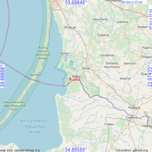
Rusnė GPS coordinates[2]
55° 17' 53.52" North, 21° 22' 16.32" East
| Map corner | latitude | longitude |
|---|---|---|
| Upper-left | 55.69648°, | 20.66808° |
| Center: | 55.2982°, | 21.3712° |
| Lower-right: | 54.89588°, | 22.07433° |
| Map W x H: | 89×89 km | = 55.3×55.3mi |
| max Lat: | 56.36149° ⇑43.3% North |
| Rusnė: | 55.2982° |
| min Lat: | ⇓56.7% South 54.01573° |
| min Long | Rusnė | max Long |
| 20.99651° | 21.3712° | 26.43984° |
| W 6%⇐ | ⇒94% E |
Elevation
Elevation of Rusnė is 0 m = 0 ft, and this is 90.7 m = 298 ft below average elevation for this country.
| Max E: |
204 m = 669 ft | 98.5% |
| Avg. | 90.7 m = 298 ft | |
| Rusnė | 0 m = 0 ft | |
Min E: |
-1 m = -3 ft | 1.5% |
See also: Lithuania elevation on elevation.city.
Geographical zone
Rusnė is located in North temperate zone (between Tropic of Cancer and the Arctic Circle). Distance of this North polar circle is 1252.6 km =778.3 mi to North.| Distance of | km | miles | from Rusnė |
|---|---|---|---|
| North Pole | 3858.5 | 2397.6 | to North |
| Arctic Circle | 1252.6 | 778.3 | to North |
| Tropic Cancer | 3542.7 | 2201.3 | to South |
| Equator | 6148.6 | 3820.6 | to South |


Nearby cities:
15 places around Rusnė: (largest is in red/bold)
• Gargždai
45.8 km =28.5 mi,  1°
1°
• Juodkrantė
31 km =19.3 mi,  328°
328°
• Klaipėda
47.7 km =29.6 mi,  342°
342°
• Kretinga
66.1 km =41.1 mi,  353°
353°
• Neringa
21 km =13 mi,  292°
292°
• Nida
23.7 km =14.7 mi,  272°
272°
• Pagėgiai
38.8 km =24.1 mi,  117°
117°
• Palanga
71.4 km =44.4 mi, 344°
• Plunge
74.4 km =46.2 mi,  23°
23°
• Priekulė
28.7 km =17.8 mi, 353°
• Rietavas
59 km =36.7 mi,  36°
36°
• Silute
9 km =5.6 mi,  51°
51°
• Taurage
58.4 km =36.3 mi,  95°
95°
• Šilalė
55.7 km =34.6 mi,  67°
67°
• Žemaičių Naumiestis
22.1 km =13.7 mi, 72°
Sources, notices
• [Note1] Compared only with cities in Lithuania existing in our database
• [Src1] Map data: © OpenStreetMap contributors (CC-BY-SA)
• [Src2] Other city data from geonames.org with taken over terms of usage.
• [Src3] Geographical zone / Annual Mean Temperature by Robert A. Rohde @ Wikipedia
