Gargždai geodata
Gargždai (Klaipėda County) is a populated place; located in Lithuania in Europe/Vilnius (GMT+3) time zone. With population of 16,433 people, there are 33 cities with bigger population in this country. Compared to other cities in Lithuania, 73.1% of cities are located further ↓South; 93.3% of cities are located further →East and 89.6% of cities have higher elevation than Gargždai. Note1


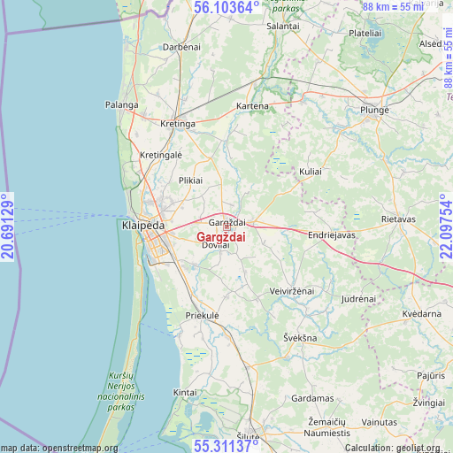
Gargždai GPS coordinates[2]
55° 42' 34.236" North, 21° 23' 39.876" East
| Map corner | latitude | longitude |
|---|---|---|
| Upper-left | 56.10364°, | 20.69129° |
| Center: | 55.70951°, | 21.39441° |
| Lower-right: | 55.31137°, | 22.09754° |
| Map W x H: | 88.1×88.1 km | = 54.7×54.7mi |
| max Lat: | 56.36149° ⇑26.9% North |
| Gargždai: | 55.70951° |
| min Lat: | ⇓73.1% South 54.01573° |
| min Long | Gargždai | max Long |
| 20.99651° | 21.39441° | 26.43984° |
| W 6.7%⇐ | ⇒93.3% E |
Elevation
Elevation of Gargždai is 27 m = 89 ft, and this is 63.7 m = 209 ft below average elevation for this country.
| Max E: |
204 m = 669 ft | 89.6% |
| Avg. | 90.7 m = 298 ft | |
| Gargždai | 27 m = 89 ft | |
Min E: |
-1 m = -3 ft | 10.4% |
See also: Lithuania elevation on elevation.city.
Geographical zone
Gargždai is located in North temperate zone (between Tropic of Cancer and the Arctic Circle). Distance of this North polar circle is 1206.9 km =749.9 mi to North.| Distance of | km | miles | from Gargždai |
|---|---|---|---|
| North Pole | 3812.7 | 2369.1 | to North |
| Arctic Circle | 1206.9 | 749.9 | to North |
| Tropic Cancer | 3588.4 | 2229.7 | to South |
| Equator | 6194.3 | 3849 | to South |


Nearby cities:
15 places around Gargždai: (largest is in red/bold)
• Juodkrantė
25.8 km =16 mi,  222°
222°
• Klaipėda
16 km =9.9 mi,  268°
268°
• Kretinga
22 km =13.7 mi,  334°
334°
• Neringa
42.9 km =26.7 mi,  208°
208°
• Nida
51.1 km =31.8 mi, 209°
• Palanga
30.8 km =19.1 mi,  318°
318°
• Plateliai
45.8 km =28.5 mi,  35°
35°
• Plunge
36 km =22.4 mi,  51°
51°
• Priekulė
17.9 km =11.1 mi,  195°
195°
• Rietavas
33.2 km =20.6 mi,  86°
86°
• Rusnė
45.8 km =28.5 mi,  181°
181°
• Salantai
40.1 km =24.9 mi,  15°
15°
• Silute
40.5 km =25.2 mi,  172°
172°
• Šventoji
40.2 km =25 mi, 331°
• Žemaičių Naumiestis
43.5 km =27 mi,  153°
153°
Sources, notices
• [Note1] Compared only with cities in Lithuania existing in our database
• [Src1] Map data: © OpenStreetMap contributors (CC-BY-SA)
• [Src2] Other city data from geonames.org with taken over terms of usage.
• [Src3] Geographical zone / Annual Mean Temperature by Robert A. Rohde @ Wikipedia
