Nida geodata
Nida (Klaipėda County) is a seat of a second-order administrative division; located in Lithuania in Europe/Vilnius (GMT+3) time zone. With population of 1,650 people, there are 103 cities with bigger population in this country. Compared to other cities in Lithuania, 57.5% of cities are located further ↓South; 100% of cities are located further →East and 88.1% of cities have higher elevation than Nida. Note1


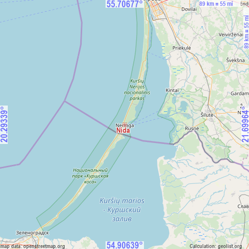
Nida GPS coordinates[2]
55° 18' 30.96" North, 20° 59' 47.436" East
| Map corner | latitude | longitude |
|---|---|---|
| Upper-left | 55.70677°, | 20.29339° |
| Center: | 55.3086°, | 20.99651° |
| Lower-right: | 54.90639°, | 21.69964° |
| Map W x H: | 89×89 km | = 55.3×55.3mi |
| max Lat: | 56.36149° ⇑42.5% North |
| Nida: | 55.3086° |
| min Lat: | ⇓57.5% South 54.01573° |
| min Long | Nida | max Long |
| 20.99651° | 20.99651° | 26.43984° |
| W 0%⇐ | ⇒100% E |
Elevation
Elevation of Nida is 31 m = 102 ft, and this is 59.7 m = 196 ft below average elevation for this country.
| Max E: |
204 m = 669 ft | 88.1% |
| Avg. | 90.7 m = 298 ft | |
| Nida | 31 m = 102 ft | |
Min E: |
-1 m = -3 ft | 11.9% |
See also: Lithuania elevation on elevation.city.
Geographical zone
Nida is located in North temperate zone (between Tropic of Cancer and the Arctic Circle). Distance of this North polar circle is 1251.4 km =777.6 mi to North.| Distance of | km | miles | from Nida |
|---|---|---|---|
| North Pole | 3857.3 | 2396.8 | to North |
| Arctic Circle | 1251.4 | 777.6 | to North |
| Tropic Cancer | 3543.8 | 2202 | to South |
| Equator | 6149.7 | 3821.2 | to South |


Nearby cities:
15 places around Nida: (largest is in red/bold)
• Gargždai
51.1 km =31.8 mi,  29°
29°
• Juodkrantė
26.6 km =16.5 mi,  16°
16°
• Klaipėda
45.2 km =28.1 mi,  11°
11°
• Kretinga
66.4 km =41.3 mi, 13°
• Neringa
8.3 km =5.2 mi, 31°
• Pagėgiai
61.2 km =38 mi,  108°
108°
• Palanga
67.9 km =42.2 mi,  3°
3°
• Priekulė
34.1 km =21.2 mi,  36°
36°
• Rietavas
74.6 km =46.4 mi,  51°
51°
• Rusnė
23.7 km =14.7 mi,  92°
92°
• Silute
31.1 km =19.3 mi,  81°
81°
• Taurage
82.1 km =51 mi, 94°
• Šilalė
77.8 km =48.3 mi,  74°
74°
• Šventoji
80 km =49.7 mi, 3°
• Žemaičių Naumiestis
45.1 km =28 mi, 82°
Sources, notices
• [Note1] Compared only with cities in Lithuania existing in our database
• [Src1] Map data: © OpenStreetMap contributors (CC-BY-SA)
• [Src2] Other city data from geonames.org with taken over terms of usage.
• [Src3] Geographical zone / Annual Mean Temperature by Robert A. Rohde @ Wikipedia
