Rietavas geodata
Rietavas (Telsiai) is a seat of a second-order administrative division; located in Lithuania in Europe/Vilnius (GMT+3) time zone. With population of 3,737 people, there are 76 cities with bigger population in this country. Compared to other cities in Lithuania, 73.9% of cities are located further ↓South; 87.3% of cities are located further →East and 67.2% of cities have lower elevation than Rietavas. Note1


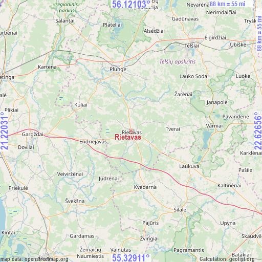
Rietavas GPS coordinates[2]
55° 43' 37.488" North, 21° 55' 24.348" East
| Map corner | latitude | longitude |
|---|---|---|
| Upper-left | 56.12103°, | 21.22031° |
| Center: | 55.72708°, | 21.92343° |
| Lower-right: | 55.32911°, | 22.62656° |
| Map W x H: | 88.1×88.1 km | = 54.7×54.7mi |
| max Lat: | 56.36149° ⇑26.1% North |
| Rietavas: | 55.72708° |
| min Lat: | ⇓73.9% South 54.01573° |
| min Long | Rietavas | max Long |
| 20.99651° | 21.92343° | 26.43984° |
| W 12.7%⇐ | ⇒87.3% E |
Elevation
Elevation of Rietavas is 112 m = 367 ft, and this is 21.3 m = 70 ft above average elevation for this country.
| Max E: |
204 m = 669 ft | 32.8% |
| Rietavas | 112 m 367 ft | |
| Avg. | 90.7 m = 298 ft | |
Min E: |
-1 m = -3 ft | 67.2% |
See also: Lithuania elevation on elevation.city.
Geographical zone
Rietavas is located in North temperate zone (between Tropic of Cancer and the Arctic Circle). Distance of this North polar circle is 1204.9 km =748.7 mi to North.| Distance of | km | miles | from Rietavas |
|---|---|---|---|
| North Pole | 3810.8 | 2367.9 | to North |
| Arctic Circle | 1204.9 | 748.7 | to North |
| Tropic Cancer | 3590.4 | 2231 | to South |
| Equator | 6196.3 | 3850.2 | to South |


Nearby cities:
15 places around Rietavas: (largest is in red/bold)
• Gargždai
33.2 km =20.6 mi,  266°
266°
• Juodkrantė
54.8 km =34.1 mi,  247°
247°
• Klaipėda
49.2 km =30.6 mi, 267°
• Kretinga
46.1 km =28.6 mi,  292°
292°
• Plateliai
36.1 km =22.4 mi,  349°
349°
• Plunge
21.1 km =13.1 mi, 346°
• Priekulė
42.5 km =26.4 mi,  243°
243°
• Salantai
42.8 km =26.6 mi,  328°
328°
• Seda
50.2 km =31.2 mi,  11°
11°
• Silute
50.4 km =31.3 mi,  213°
213°
• Telsiai
34.8 km =21.6 mi,  35°
35°
• Užventis
46 km =28.6 mi,  82°
82°
• Varniai
28.2 km =17.5 mi,  86°
86°
• Šilalė
31.1 km =19.3 mi,  147°
147°
• Žemaičių Naumiestis
43.2 km =26.8 mi,  198°
198°
Sources, notices
• [Note1] Compared only with cities in Lithuania existing in our database
• [Src1] Map data: © OpenStreetMap contributors (CC-BY-SA)
• [Src2] Other city data from geonames.org with taken over terms of usage.
• [Src3] Geographical zone / Annual Mean Temperature by Robert A. Rohde @ Wikipedia
