Šventoji geodata
Šventoji (Klaipėda County) is a populated place; located in Lithuania in Europe/Vilnius (GMT+3) time zone. With population of 2,000 people, there are 93 cities with bigger population in this country. Compared to other cities in Lithuania, 88.1% of cities are located further ↓South; 97.8% of cities are located further →East and 97.8% of cities have higher elevation than Šventoji. Note1


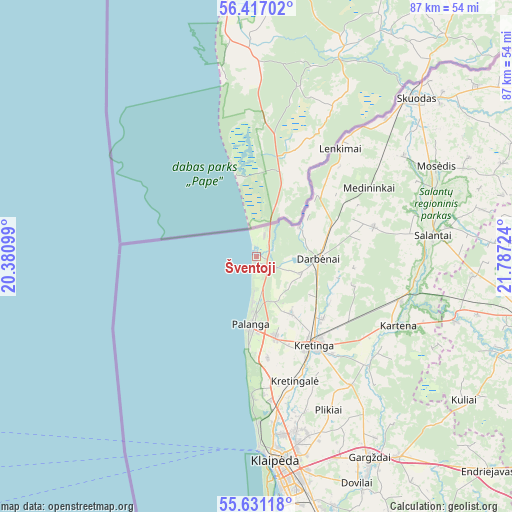
Šventoji GPS coordinates[2]
56° 1' 33.96" North, 21° 5' 2.796" East
| Map corner | latitude | longitude |
|---|---|---|
| Upper-left | 56.41702°, | 20.38099° |
| Center: | 56.0261°, | 21.08411° |
| Lower-right: | 55.63118°, | 21.78724° |
| Map W x H: | 87.4×87.4 km | = 54.3×54.3mi |
| max Lat: | 56.36149° ⇑11.9% North |
| Šventoji: | 56.0261° |
| min Lat: | ⇓88.1% South 54.01573° |
| min Long | Šventoji | max Long |
| 20.99651° | 21.08411° | 26.43984° |
| W 2.2%⇐ | ⇒97.8% E |
Elevation
Elevation of Šventoji is 3 m = 10 ft, and this is 87.7 m = 288 ft below average elevation for this country.
| Max E: |
204 m = 669 ft | 97.8% |
| Avg. | 90.7 m = 298 ft | |
| Šventoji | 3 m = 10 ft | |
Min E: |
-1 m = -3 ft | 2.2% |
See also: Lithuania elevation on elevation.city.
Geographical zone
Šventoji is located in North temperate zone (between Tropic of Cancer and the Arctic Circle). Distance of this North polar circle is 1171.7 km =728.1 mi to North.| Distance of | km | miles | from Šventoji |
|---|---|---|---|
| North Pole | 3777.5 | 2347.2 | to North |
| Arctic Circle | 1171.7 | 728.1 | to North |
| Tropic Cancer | 3623.6 | 2251.6 | to South |
| Equator | 6229.5 | 3870.8 | to South |


Nearby cities:
15 places around Šventoji: (largest is in red/bold)
• Gargždai
40.2 km =25 mi,  151°
151°
• Juodkrantė
54.4 km =33.8 mi,  177°
177°
• Klaipėda
35.7 km =22.2 mi,  174°
174°
• Kretinga
18.2 km =11.3 mi, 146°
• Neringa
72.7 km =45.2 mi, 180°
• Palanga
12.1 km =7.5 mi, 184°
• Plateliai
45.5 km =28.3 mi,  87°
87°
• Plunge
49 km =30.4 mi,  105°
105°
• Priekulė
54.5 km =33.9 mi,  164°
164°
• Rietavas
62 km =38.5 mi,  122°
122°
• Salantai
30.3 km =18.8 mi,  83°
83°
• Seda
64.4 km =40 mi, 75°
• Silute
79.3 km =49.3 mi, 161°
• Skuodas
38.8 km =24.1 mi,  45°
45°
• Telsiai
72.5 km =45 mi, 93°
Sources, notices
• [Note1] Compared only with cities in Lithuania existing in our database
• [Src1] Map data: © OpenStreetMap contributors (CC-BY-SA)
• [Src2] Other city data from geonames.org with taken over terms of usage.
• [Src3] Geographical zone / Annual Mean Temperature by Robert A. Rohde @ Wikipedia
