Plunge geodata
Plunge (Telsiai) is a populated place; located in Lithuania in Europe/Vilnius (GMT+3) time zone. With population of 23,381 people, there are 24 cities with bigger population in this country. Compared to other cities in Lithuania, 81.3% of cities are located further ↓South; 88.8% of cities are located further →East and 62.7% of cities have lower elevation than Plunge. Note1


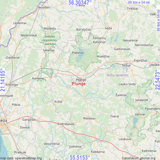
Plunge GPS coordinates[2]
55° 54' 41.004" North, 21° 50' 39.012" East
| Map corner | latitude | longitude |
|---|---|---|
| Upper-left | 56.30347°, | 21.14105° |
| Center: | 55.91139°, | 21.84417° |
| Lower-right: | 55.5153°, | 22.5473° |
| Map W x H: | 87.6×87.6 km | = 54.4×54.4mi |
| max Lat: | 56.36149° ⇑18.7% North |
| Plunge: | 55.91139° |
| min Lat: | ⇓81.3% South 54.01573° |
| min Long | Plunge | max Long |
| 20.99651° | 21.84417° | 26.43984° |
| W 11.2%⇐ | ⇒88.8% E |
Elevation
Elevation of Plunge is 106 m = 348 ft, and this is 15.3 m = 50 ft above average elevation for this country.
| Max E: |
204 m = 669 ft | 37.3% |
| Plunge | 106 m 348 ft | |
| Avg. | 90.7 m = 298 ft | |
Min E: |
-1 m = -3 ft | 62.7% |
See also: Lithuania elevation on elevation.city.
Geographical zone
Plunge is located in North temperate zone (between Tropic of Cancer and the Arctic Circle). Distance of this North polar circle is 1184.4 km =736 mi to North.| Distance of | km | miles | from Plunge |
|---|---|---|---|
| North Pole | 3790.3 | 2355.2 | to North |
| Arctic Circle | 1184.4 | 736 | to North |
| Tropic Cancer | 3610.8 | 2243.6 | to South |
| Equator | 6216.8 | 3862.9 | to South |


Nearby cities:
15 places around Plunge: (largest is in red/bold)
• Gargždai
36 km =22.4 mi,  231°
231°
• Klaipėda
49.6 km =30.8 mi,  242°
242°
• Kretinga
37.5 km =23.3 mi,  266°
266°
• Palanga
48.3 km =30 mi, 270°
• Plateliai
15.1 km =9.4 mi,  353°
353°
• Priekulė
51.6 km =32.1 mi,  219°
219°
• Rietavas
21.1 km =13.1 mi,  166°
166°
• Salantai
23.5 km =14.6 mi,  313°
313°
• Seda
32.4 km =20.1 mi,  28°
28°
• Skuodas
44.4 km =27.6 mi,  334°
334°
• Telsiai
26.3 km =16.3 mi,  72°
72°
• Užventis
52.4 km =32.6 mi,  105°
105°
• Varniai
37.9 km =23.5 mi,  119°
119°
• Šilalė
51.6 km =32.1 mi,  155°
155°
• Šventoji
49 km =30.4 mi,  285°
285°
Sources, notices
• [Note1] Compared only with cities in Lithuania existing in our database
• [Src1] Map data: © OpenStreetMap contributors (CC-BY-SA)
• [Src2] Other city data from geonames.org with taken over terms of usage.
• [Src3] Geographical zone / Annual Mean Temperature by Robert A. Rohde @ Wikipedia
