Steinsel geodata
Steinsel (Luxembourg) is a seat of a third-order administrative division; located in Luxembourg in Europe/Luxembourg (GMT+2) time zone. With population of 1,879 people, there are 40 cities with bigger population in this country. Compared to other cities in Luxembourg, 53.7% of cities are located further ↓South; 51.4% of cities are located further ←West and 72.9% of cities have higher elevation than Steinsel. Note1


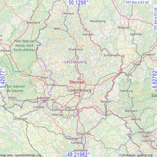
Steinsel GPS coordinates[2]
49° 40' 36.984" North, 6° 7' 26.004" East
| Map corner | latitude | longitude |
|---|---|---|
| Upper-left | 50.1298°, | 5.42077° |
| Center: | 49.67694°, | 6.12389° |
| Lower-right: | 49.21982°, | 6.82702° |
| Map W x H: | 101.2×101.2 km | = 62.9×62.9mi |
| max Lat: | 50.13722° ⇑46.3% North |
| Steinsel: | 49.67694° |
| min Lat: | ⇓53.7% South 49.45964° |
| min Long | Steinsel | max Long |
| 5.76583° | 6.12389° | 6.50532° |
| W 51.4%⇐ | ⇒48.6% E |
Elevation
Elevation of Steinsel is 243 m = 797 ft, and this is 39 m = 128 ft below average elevation for this country.
| Max E: |
502 m = 1647 ft | 72.9% |
| Avg. | 282 m = 925 ft | |
| Steinsel | 243 m = 797 ft | |
Min E: |
143 m = 469 ft | 27.1% |
See also: Luxembourg elevation on elevation.city.
Geographical zone
Steinsel is located in North temperate zone (between Tropic of Cancer and the Arctic Circle). Distance of this North polar circle is 1877.6 km =1166.7 mi to North.| Distance of | km | miles | from Steinsel |
|---|---|---|---|
| North Pole | 4483.5 | 2785.9 | to North |
| Arctic Circle | 1877.6 | 1166.7 | to North |
| Tropic Cancer | 2917.6 | 1812.9 | to South |
| Equator | 5523.6 | 3432.2 | to South |


Nearby cities:
15 places around Steinsel: (largest is in red/bold)
• Bofferdange
1.9 km =1.2 mi,  37°
37°
• Bridel
3.9 km =2.4 mi,  233°
233°
• Béreldange
2.5 km =1.6 mi,  188°
188°
• Heisdorf
1.4 km =0.9 mi,  112°
112°
• Helmdange
2.3 km =1.4 mi,  34°
34°
• Helmsange
3 km =1.9 mi,  154°
154°
• Kehlen
6.4 km =4 mi,  261°
261°
• Keispelt
4.4 km =2.7 mi,  295°
295°
• Kirchberg
6.2 km =3.9 mi,  162°
162°
• Kopstal
3.9 km =2.4 mi,  249°
249°
• Lintgen
5.1 km =3.2 mi,  5°
5°
• Lorentzweiler
3 km =1.9 mi, 26°
• Müllendorf
0.6 km =0.4 mi,  49°
49°
• Strassen
7.2 km =4.5 mi,  210°
210°
• Walferdange
1.6 km =1 mi, 158°
Sources, notices
• [Note1] Compared only with cities in Luxembourg existing in our database
• [Src1] Map data: © OpenStreetMap contributors (CC-BY-SA)
• [Src2] Other city data from geonames.org with taken over terms of usage.
• [Src3] Geographical zone / Annual Mean Temperature by Robert A. Rohde @ Wikipedia
