Kehlen geodata
Kehlen (Capellen) is a seat of a third-order administrative division; located in Luxembourg in Europe/Luxembourg (GMT+2) time zone. With population of 1,658 people, there are 45 cities with bigger population in this country. Compared to other cities in Luxembourg, 51.4% of cities are located further ↓South; 65% of cities are located further →East and 80.8% of cities have lower elevation than Kehlen. Note1


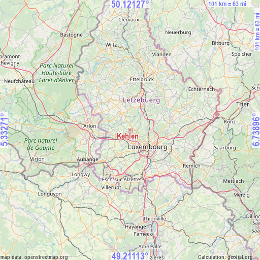
Kehlen GPS coordinates[2]
49° 40' 5.988" North, 6° 2' 8.988" East
| Map corner | latitude | longitude |
|---|---|---|
| Upper-left | 50.12127°, | 5.33271° |
| Center: | 49.66833°, | 6.03583° |
| Lower-right: | 49.21113°, | 6.73896° |
| Map W x H: | 101.2×101.2 km | = 62.9×62.9mi |
| max Lat: | 50.13722° ⇑48.6% North |
| Kehlen: | 49.66833° |
| min Lat: | ⇓51.4% South 49.45964° |
| min Long | Kehlen | max Long |
| 5.76583° | 6.03583° | 6.50532° |
| W 35%⇐ | ⇒65% E |
Elevation
Elevation of Kehlen is 329 m = 1079 ft, and this is 47 m = 154 ft above average elevation for this country.
| Max E: |
502 m = 1647 ft | 19.2% |
| Kehlen | 329 m 1079 ft | |
| Avg. | 282 m = 925 ft | |
Min E: |
143 m = 469 ft | 80.8% |
See also: Luxembourg elevation on elevation.city.
Geographical zone
Kehlen is located in North temperate zone (between Tropic of Cancer and the Arctic Circle). Distance of this North polar circle is 1878.6 km =1167.3 mi to North.| Distance of | km | miles | from Kehlen |
|---|---|---|---|
| North Pole | 4484.5 | 2786.5 | to North |
| Arctic Circle | 1878.6 | 1167.3 | to North |
| Tropic Cancer | 2916.7 | 1812.4 | to South |
| Equator | 5522.6 | 3431.6 | to South |


Nearby cities:
15 places around Kehlen: (largest is in red/bold)
• Bertrange
6.4 km =4 mi,  170°
170°
• Bridel
3.5 km =2.2 mi,  113°
113°
• Béreldange
6.1 km =3.8 mi,  103°
103°
• Capellen
4.1 km =2.5 mi,  231°
231°
• Holzem
6.6 km =4.1 mi,  209°
209°
• Keispelt
3.7 km =2.3 mi,  39°
39°
• Koerich
6.2 km =3.9 mi,  271°
271°
• Kopstal
2.7 km =1.7 mi, 99°
• Mamer
4.6 km =2.9 mi,  191°
191°
• Nospelt
2.1 km =1.3 mi,  291°
291°
• Olm
2.8 km =1.7 mi,  244°
244°
• Septfontaines
6.1 km =3.8 mi,  306°
306°
• Steinsel
6.4 km =4 mi,  81°
81°
• Strassen
6 km =3.7 mi,  153°
153°
• Tuntange
5.8 km =3.6 mi,  341°
341°
Sources, notices
• [Note1] Compared only with cities in Luxembourg existing in our database
• [Src1] Map data: © OpenStreetMap contributors (CC-BY-SA)
• [Src2] Other city data from geonames.org with taken over terms of usage.
• [Src3] Geographical zone / Annual Mean Temperature by Robert A. Rohde @ Wikipedia
