Lorentzweiler geodata
Lorentzweiler (Mersch) is a seat of a third-order administrative division; located in Luxembourg in Europe/Luxembourg (GMT+2) time zone. With population of 772 people, there are 103 cities with bigger population in this country. Compared to other cities in Luxembourg, 60.5% of cities are located further ↓South; 58.8% of cities are located further ←West and 75.7% of cities have higher elevation than Lorentzweiler. Note1


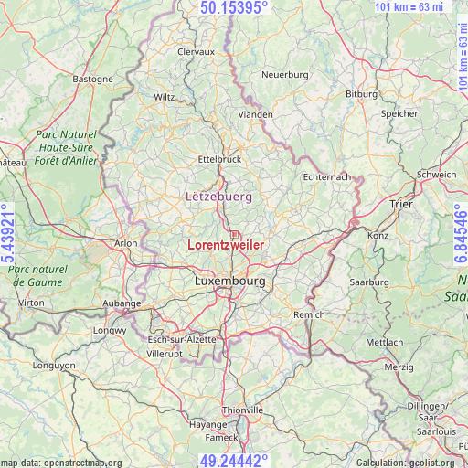
Lorentzweiler GPS coordinates[2]
49° 42' 4.716" North, 6° 8' 32.424" East
| Map corner | latitude | longitude |
|---|---|---|
| Upper-left | 50.15395°, | 5.43921° |
| Center: | 49.70131°, | 6.14234° |
| Lower-right: | 49.24442°, | 6.84546° |
| Map W x H: | 101.1×101.1 km | = 62.8×62.8mi |
| max Lat: | 50.13722° ⇑39.5% North |
| Lorentzweiler: | 49.70131° |
| min Lat: | ⇓60.5% South 49.45964° |
| min Long | Lorentzweiler | max Long |
| 5.76583° | 6.14234° | 6.50532° |
| W 58.8%⇐ | ⇒41.2% E |
Elevation
Elevation of Lorentzweiler is 233 m = 764 ft, and this is 49 m = 161 ft below average elevation for this country.
| Max E: |
502 m = 1647 ft | 75.7% |
| Avg. | 282 m = 925 ft | |
| Lorentzweiler | 233 m = 764 ft | |
Min E: |
143 m = 469 ft | 24.3% |
See also: Luxembourg elevation on elevation.city.
Geographical zone
Lorentzweiler is located in North temperate zone (between Tropic of Cancer and the Arctic Circle). Distance of this North polar circle is 1874.9 km =1165 mi to North.| Distance of | km | miles | from Lorentzweiler |
|---|---|---|---|
| North Pole | 4480.8 | 2784.2 | to North |
| Arctic Circle | 1874.9 | 1165 | to North |
| Tropic Cancer | 2920.3 | 1814.6 | to South |
| Equator | 5526.3 | 3433.9 | to South |


Nearby cities:
15 places around Lorentzweiler: (largest is in red/bold)
• Bofferdange
1.2 km =0.7 mi,  188°
188°
• Bourglinster
5.4 km =3.4 mi,  87°
87°
• Béreldange
5.4 km =3.4 mi,  198°
198°
• Fischbach
5.9 km =3.7 mi,  32°
32°
• Heisdorf
3.3 km =2.1 mi,  180°
180°
• Helmdange
0.8 km =0.5 mi, 183°
• Helmsange
5.4 km =3.4 mi, 180°
• Keispelt
5.4 km =3.4 mi,  261°
261°
• Kopstal
6.5 km =4 mi,  230°
230°
• Lintgen
2.5 km =1.6 mi,  339°
339°
• Mersch
5.9 km =3.7 mi,  333°
333°
• Müllendorf
2.5 km =1.6 mi, 200°
• Rollingen
4.9 km =3 mi, 335°
• Steinsel
3 km =1.9 mi,  206°
206°
• Walferdange
4.3 km =2.7 mi, 189°
Sources, notices
• [Note1] Compared only with cities in Luxembourg existing in our database
• [Src1] Map data: © OpenStreetMap contributors (CC-BY-SA)
• [Src2] Other city data from geonames.org with taken over terms of usage.
• [Src3] Geographical zone / Annual Mean Temperature by Robert A. Rohde @ Wikipedia
