Schengen geodata
Schengen (Remich) is a seat of a third-order administrative division; located in Luxembourg in Europe/Luxembourg (GMT+2) time zone. With population of 470 people, there are 150 cities with bigger population in this country. Compared to other cities in Luxembourg, 99.4% of cities are located further ↑North; 90.4% of cities are located further ←West and 93.2% of cities have higher elevation than Schengen. Note1


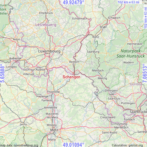
Schengen GPS coordinates[2]
49° 28' 12" North, 6° 21' 43.2" East
| Map corner | latitude | longitude |
|---|---|---|
| Upper-left | 49.92479°, | 5.65888° |
| Center: | 49.47°, | 6.362° |
| Lower-right: | 49.01094°, | 7.06513° |
| Map W x H: | 101.6×101.6 km | = 63.1×63.1mi |
| max Lat: | 50.13722° ⇑99.4% North |
| Schengen: | 49.47° |
| min Lat: | ⇓0.6% South 49.45964° |
| min Long | Schengen | max Long |
| 5.76583° | 6.362° | 6.50532° |
| W 90.4%⇐ | ⇒9.6% E |
Elevation
Elevation of Schengen is 172 m = 564 ft, and this is 110 m = 361 ft below average elevation for this country.
| Max E: |
502 m = 1647 ft | 93.2% |
| Avg. | 282 m = 925 ft | |
| Schengen | 172 m = 564 ft | |
Min E: |
143 m = 469 ft | 6.8% |
See also: Luxembourg elevation on elevation.city.
Geographical zone
Schengen is located in North temperate zone (between Tropic of Cancer and the Arctic Circle). Distance of this North polar circle is 1900.6 km =1181 mi to North.| Distance of | km | miles | from Schengen |
|---|---|---|---|
| North Pole | 4506.5 | 2800.2 | to North |
| Arctic Circle | 1900.6 | 1181 | to North |
| Tropic Cancer | 2894.6 | 1798.6 | to South |
| Equator | 5500.5 | 3417.9 | to South |


Nearby cities:
15 places around Schengen: (largest is in red/bold)
• Altwies
8.8 km =5.5 mi,  300°
300°
• Aspelt
11.5 km =7.1 mi, 300°
• Bech-Kleinmacher
6.8 km =4.2 mi,  355°
355°
• Bous
9.6 km =6 mi,  345°
345°
• Dalheim
10.8 km =6.7 mi,  316°
316°
• Elvange
5.1 km =3.2 mi, 319°
• Frisange
13.5 km =8.4 mi,  292°
292°
• Greiveldange
12.7 km =7.9 mi, 359°
• Lenningen
14.5 km =9 mi,  1°
1°
• Mondorf-les-Bains
7 km =4.3 mi, 303°
• Remerschen
2.2 km =1.4 mi,  340°
340°
• Remich
8.3 km =5.2 mi, 2°
• Stadtbredimus
10.3 km =6.4 mi, 0°
• Waldbredimus
11 km =6.8 mi,  330°
330°
• Weiler-la-Tour
14.1 km =8.8 mi, 304°
Sources, notices
• [Note1] Compared only with cities in Luxembourg existing in our database
• [Src1] Map data: © OpenStreetMap contributors (CC-BY-SA)
• [Src2] Other city data from geonames.org with taken over terms of usage.
• [Src3] Geographical zone / Annual Mean Temperature by Robert A. Rohde @ Wikipedia
