Mondorf-les-Bains geodata
Mondorf-les-Bains (Remich) is a seat of a third-order administrative division; located in Luxembourg in Europe/Luxembourg (GMT+2) time zone. With population of 3,113 people, there are 27 cities with bigger population in this country. Compared to other cities in Luxembourg, 96% of cities are located further ↑North; 81.4% of cities are located further ←West and 90.4% of cities have higher elevation than Mondorf-les-Bains. Note1


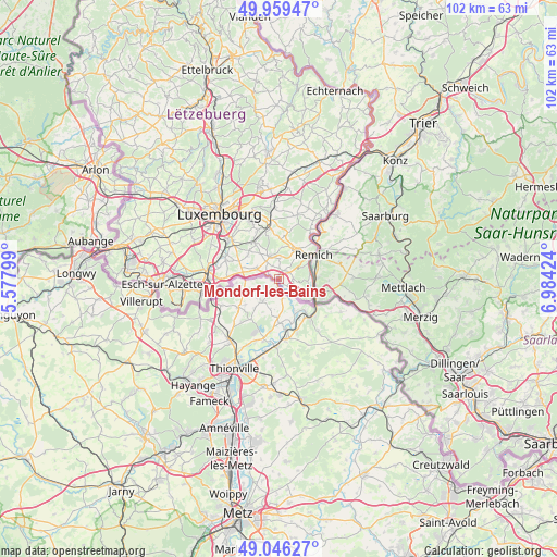
Mondorf-les-Bains GPS coordinates[2]
49° 30' 18" North, 6° 16' 51.996" East
| Map corner | latitude | longitude |
|---|---|---|
| Upper-left | 49.95947°, | 5.57799° |
| Center: | 49.505°, | 6.28111° |
| Lower-right: | 49.04627°, | 6.98424° |
| Map W x H: | 101.5×101.5 km | = 63.1×63.1mi |
| max Lat: | 50.13722° ⇑96% North |
| Mondorf-les-Bains: | 49.505° |
| min Lat: | ⇓4% South 49.45964° |
| min Long | Mondorf-les-Bai | max Long |
| 5.76583° | 6.28111° | 6.50532° |
| W 81.4%⇐ | ⇒18.6% E |
Elevation
Elevation of Mondorf-les-Bains is 191 m = 627 ft, and this is 91 m = 299 ft below average elevation for this country.
| Max E: |
502 m = 1647 ft | 90.4% |
| Avg. | 282 m = 925 ft | |
| Mondorf-les-Bains | 191 m = 627 ft | |
Min E: |
143 m = 469 ft | 9.6% |
See also: Luxembourg elevation on elevation.city.
Geographical zone
Mondorf-les-Bains is located in North temperate zone (between Tropic of Cancer and the Arctic Circle). Distance of this North polar circle is 1896.7 km =1178.6 mi to North.| Distance of | km | miles | from Mondorf-les-Bains |
|---|---|---|---|
| North Pole | 4502.6 | 2797.8 | to North |
| Arctic Circle | 1896.7 | 1178.6 | to North |
| Tropic Cancer | 2898.5 | 1801 | to South |
| Equator | 5504.4 | 3420.3 | to South |


Nearby cities:
15 places around Mondorf-les-Bains: (largest is in red/bold)
• Altwies
1.8 km =1.1 mi,  289°
289°
• Aspelt
4.5 km =2.8 mi,  295°
295°
• Bech-Kleinmacher
6.1 km =3.8 mi,  61°
61°
• Bous
6.4 km =4 mi,  32°
32°
• Contern
9.4 km =5.8 mi,  335°
335°
• Dalheim
4.3 km =2.7 mi, 338°
• Elvange
2.5 km =1.6 mi,  89°
89°
• Frisange
6.8 km =4.2 mi,  280°
280°
• Moutfort
9.1 km =5.7 mi,  348°
348°
• Remerschen
5.4 km =3.4 mi,  109°
109°
• Remich
7.6 km =4.7 mi,  54°
54°
• Schengen
7 km =4.3 mi,  123°
123°
• Stadtbredimus
8.8 km =5.5 mi,  43°
43°
• Waldbredimus
5.8 km =3.6 mi,  4°
4°
• Weiler-la-Tour
7 km =4.3 mi, 304°
Sources, notices
• [Note1] Compared only with cities in Luxembourg existing in our database
• [Src1] Map data: © OpenStreetMap contributors (CC-BY-SA)
• [Src2] Other city data from geonames.org with taken over terms of usage.
• [Src3] Geographical zone / Annual Mean Temperature by Robert A. Rohde @ Wikipedia
