Elvange geodata
Elvange (Remich) is a populated place; located in Luxembourg in Europe/Luxembourg (GMT+2) time zone. With population of 713 people, there are 109 cities with bigger population in this country. Compared to other cities in Luxembourg, 95.5% of cities are located further ↑North; 84.7% of cities are located further ←West and 63.3% of cities have higher elevation than Elvange. Note1


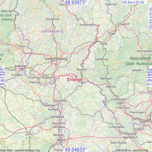
Elvange GPS coordinates[2]
49° 30' 19.008" North, 6° 18' 59.004" East
| Map corner | latitude | longitude |
|---|---|---|
| Upper-left | 49.95975°, | 5.61327° |
| Center: | 49.50528°, | 6.31639° |
| Lower-right: | 49.04655°, | 7.01952° |
| Map W x H: | 101.5×101.5 km | = 63.1×63.1mi |
| max Lat: | 50.13722° ⇑95.5% North |
| Elvange: | 49.50528° |
| min Lat: | ⇓4.5% South 49.45964° |
| min Long | Elvange | max Long |
| 5.76583° | 6.31639° | 6.50532° |
| W 84.7%⇐ | ⇒15.3% E |
Elevation
Elevation of Elvange is 263 m = 863 ft, and this is 19 m = 62 ft below average elevation for this country.
| Max E: |
502 m = 1647 ft | 63.3% |
| Avg. | 282 m = 925 ft | |
| Elvange | 263 m = 863 ft | |
Min E: |
143 m = 469 ft | 36.7% |
See also: Luxembourg elevation on elevation.city.
Geographical zone
Elvange is located in North temperate zone (between Tropic of Cancer and the Arctic Circle). Distance of this North polar circle is 1896.7 km =1178.6 mi to North.| Distance of | km | miles | from Elvange |
|---|---|---|---|
| North Pole | 4502.6 | 2797.8 | to North |
| Arctic Circle | 1896.7 | 1178.6 | to North |
| Tropic Cancer | 2898.6 | 1801.1 | to South |
| Equator | 5504.5 | 3420.3 | to South |


Nearby cities:
15 places around Elvange: (largest is in red/bold)
• Altwies
4.3 km =2.7 mi,  277°
277°
• Aspelt
6.9 km =4.3 mi,  286°
286°
• Bech-Kleinmacher
4 km =2.5 mi,  44°
44°
• Bous
5.5 km =3.4 mi,  9°
9°
• Dalheim
5.7 km =3.5 mi,  314°
314°
• Frisange
9.3 km =5.8 mi, 277°
• Greiveldange
9.3 km =5.8 mi,  19°
19°
• Mondorf-les-Bains
2.5 km =1.6 mi,  269°
269°
• Moutfort
9.9 km =6.2 mi,  333°
333°
• Remerschen
3.2 km =2 mi,  126°
126°
• Remich
5.7 km =3.5 mi, 39°
• Schengen
5.1 km =3.2 mi,  139°
139°
• Stadtbredimus
7.3 km =4.5 mi,  28°
28°
• Waldbredimus
6.1 km =3.8 mi,  340°
340°
• Weiler-la-Tour
9.2 km =5.7 mi,  295°
295°
Sources, notices
• [Note1] Compared only with cities in Luxembourg existing in our database
• [Src1] Map data: © OpenStreetMap contributors (CC-BY-SA)
• [Src2] Other city data from geonames.org with taken over terms of usage.
• [Src3] Geographical zone / Annual Mean Temperature by Robert A. Rohde @ Wikipedia
