Remerschen geodata
Remerschen (Remich) is a populated place; located in Luxembourg in Europe/Luxembourg (GMT+2) time zone. With population of 704 people, there are 111 cities with bigger population in this country. Compared to other cities in Luxembourg, 97.7% of cities are located further ↑North; 88.7% of cities are located further ←West and 96.6% of cities have higher elevation than Remerschen. Note1


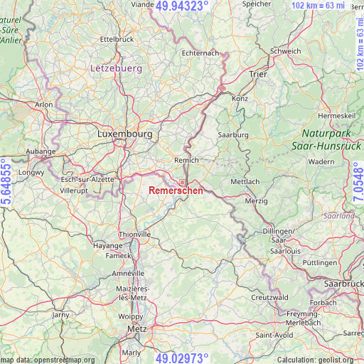
Remerschen GPS coordinates[2]
49° 29' 18.996" North, 6° 21' 6.012" East
| Map corner | latitude | longitude |
|---|---|---|
| Upper-left | 49.94323°, | 5.64855° |
| Center: | 49.48861°, | 6.35167° |
| Lower-right: | 49.02973°, | 7.0548° |
| Map W x H: | 101.6×101.6 km | = 63.1×63.1mi |
| max Lat: | 50.13722° ⇑97.7% North |
| Remerschen: | 49.48861° |
| min Lat: | ⇓2.3% South 49.45964° |
| min Long | Remerschen | max Long |
| 5.76583° | 6.35167° | 6.50532° |
| W 88.7%⇐ | ⇒11.3% E |
Elevation
Elevation of Remerschen is 154 m = 505 ft, and this is 128 m = 420 ft below average elevation for this country.
| Max E: |
502 m = 1647 ft | 96.6% |
| Avg. | 282 m = 925 ft | |
| Remerschen | 154 m = 505 ft | |
Min E: |
143 m = 469 ft | 3.4% |
See also: Luxembourg elevation on elevation.city.
Geographical zone
Remerschen is located in North temperate zone (between Tropic of Cancer and the Arctic Circle). Distance of this North polar circle is 1898.6 km =1179.7 mi to North.| Distance of | km | miles | from Remerschen |
|---|---|---|---|
| North Pole | 4504.4 | 2798.9 | to North |
| Arctic Circle | 1898.6 | 1179.7 | to North |
| Tropic Cancer | 2896.7 | 1799.9 | to South |
| Equator | 5502.6 | 3419.2 | to South |


Nearby cities:
15 places around Remerschen: (largest is in red/bold)
• Altwies
7.2 km =4.5 mi,  289°
289°
• Aspelt
9.9 km =6.2 mi, 292°
• Bech-Kleinmacher
4.7 km =2.9 mi,  2°
2°
• Bous
7.4 km =4.6 mi,  347°
347°
• Dalheim
8.8 km =5.5 mi,  311°
311°
• Elvange
3.2 km =2 mi, 306°
• Frisange
12.2 km =7.6 mi,  284°
284°
• Greiveldange
10.6 km =6.6 mi, 2°
• Lenningen
12.5 km =7.8 mi,  5°
5°
• Mondorf-les-Bains
5.4 km =3.4 mi, 289°
• Remich
6.4 km =4 mi, 9°
• Schengen
2.2 km =1.4 mi,  160°
160°
• Stadtbredimus
8.3 km =5.2 mi, 6°
• Waldbredimus
8.9 km =5.5 mi,  328°
328°
• Weiler-la-Tour
12.3 km =7.6 mi,  298°
298°
Sources, notices
• [Note1] Compared only with cities in Luxembourg existing in our database
• [Src1] Map data: © OpenStreetMap contributors (CC-BY-SA)
• [Src2] Other city data from geonames.org with taken over terms of usage.
• [Src3] Geographical zone / Annual Mean Temperature by Robert A. Rohde @ Wikipedia
