Ehlerange geodata
Ehlerange (Esch-sur-Alzette) is a populated place; located in Luxembourg in Europe/Luxembourg (GMT+2) time zone. With population of 756 people, there are 106 cities with bigger population in this country. Compared to other cities in Luxembourg, 88.7% of cities are located further ↑North; 79.7% of cities are located further →East and 61% of cities have lower elevation than Ehlerange. Note1


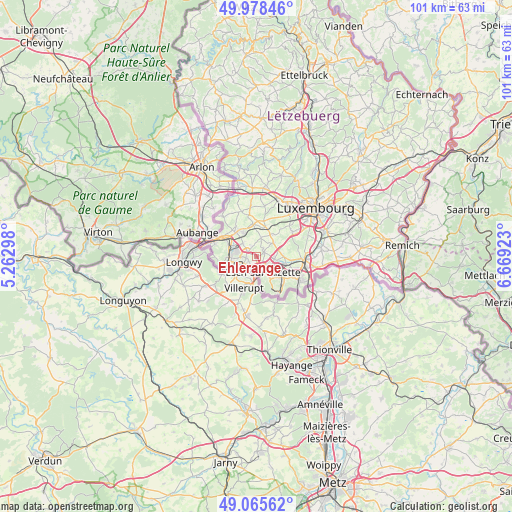
Ehlerange GPS coordinates[2]
49° 31' 27.012" North, 5° 57' 57.996" East
| Map corner | latitude | longitude |
|---|---|---|
| Upper-left | 49.97846°, | 5.26298° |
| Center: | 49.52417°, | 5.96611° |
| Lower-right: | 49.06562°, | 6.66923° |
| Map W x H: | 101.5×101.5 km | = 63.1×63.1mi |
| max Lat: | 50.13722° ⇑88.7% North |
| Ehlerange: | 49.52417° |
| min Lat: | ⇓11.3% South 49.45964° |
| min Long | Ehlerange | max Long |
| 5.76583° | 5.96611° | 6.50532° |
| W 20.3%⇐ | ⇒79.7% E |
Elevation
Elevation of Ehlerange is 298 m = 978 ft, and this is 16 m = 52 ft above average elevation for this country.
| Max E: |
502 m = 1647 ft | 39% |
| Ehlerange | 298 m 978 ft | |
| Avg. | 282 m = 925 ft | |
Min E: |
143 m = 469 ft | 61% |
See also: Luxembourg elevation on elevation.city.
Geographical zone
Ehlerange is located in North temperate zone (between Tropic of Cancer and the Arctic Circle). Distance of this North polar circle is 1894.6 km =1177.2 mi to North.| Distance of | km | miles | from Ehlerange |
|---|---|---|---|
| North Pole | 4500.5 | 2796.5 | to North |
| Arctic Circle | 1894.6 | 1177.2 | to North |
| Tropic Cancer | 2900.7 | 1802.4 | to South |
| Equator | 5506.6 | 3421.6 | to South |


Nearby cities:
15 places around Ehlerange: (largest is in red/bold)
• Bascharage
6.4 km =4 mi,  318°
318°
• Belvaux
3.4 km =2.1 mi,  242°
242°
• Bergem
5.5 km =3.4 mi,  89°
89°
• Bettange-sur-Mess
5.9 km =3.7 mi,  12°
12°
• Differdange
5.4 km =3.4 mi,  270°
270°
• Esch-sur-Alzette
3.3 km =2.1 mi,  161°
161°
• Mondercange
1.9 km =1.2 mi,  58°
58°
• Niedercorn
5.4 km =3.4 mi,  284°
284°
• Obercorn
5.2 km =3.2 mi,  256°
256°
• Pontpierre
4.8 km =3 mi,  73°
73°
• Reckange-sur-Mess
5.3 km =3.3 mi,  35°
35°
• Sanem
3.8 km =2.4 mi,  314°
314°
• Schifflange
3.9 km =2.4 mi,  120°
120°
• Schouweiler
6.5 km =4 mi,  353°
353°
• Soleuvre
2.1 km =1.3 mi, 261°
Sources, notices
• [Note1] Compared only with cities in Luxembourg existing in our database
• [Src1] Map data: © OpenStreetMap contributors (CC-BY-SA)
• [Src2] Other city data from geonames.org with taken over terms of usage.
• [Src3] Geographical zone / Annual Mean Temperature by Robert A. Rohde @ Wikipedia
