Mondercange geodata
Mondercange (Esch-sur-Alzette) is a seat of a third-order administrative division; located in Luxembourg in Europe/Luxembourg (GMT+2) time zone. With population of 3,306 people, there are 24 cities with bigger population in this country. Compared to other cities in Luxembourg, 85.9% of cities are located further ↑North; 75.1% of cities are located further →East and 54.8% of cities have lower elevation than Mondercange. Note1


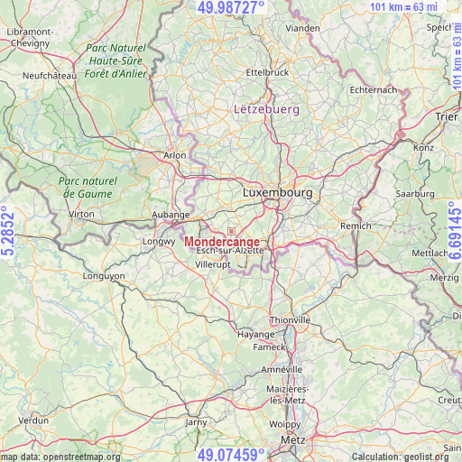
Mondercange GPS coordinates[2]
49° 31' 59.016" North, 5° 59' 17.988" East
| Map corner | latitude | longitude |
|---|---|---|
| Upper-left | 49.98727°, | 5.2852° |
| Center: | 49.53306°, | 5.98833° |
| Lower-right: | 49.07459°, | 6.69145° |
| Map W x H: | 101.5×101.5 km | = 63.1×63.1mi |
| max Lat: | 50.13722° ⇑85.9% North |
| Mondercange: | 49.53306° |
| min Lat: | ⇓14.1% South 49.45964° |
| min Long | Mondercange | max Long |
| 5.76583° | 5.98833° | 6.50532° |
| W 24.9%⇐ | ⇒75.1% E |
Elevation
Elevation of Mondercange is 290 m = 951 ft, and this is 8 m = 26 ft above average elevation for this country.
| Max E: |
502 m = 1647 ft | 45.2% |
| Mondercange | 290 m 951 ft | |
| Avg. | 282 m = 925 ft | |
Min E: |
143 m = 469 ft | 54.8% |
See also: Luxembourg elevation on elevation.city.
Geographical zone
Mondercange is located in North temperate zone (between Tropic of Cancer and the Arctic Circle). Distance of this North polar circle is 1893.6 km =1176.6 mi to North.| Distance of | km | miles | from Mondercange |
|---|---|---|---|
| North Pole | 4499.5 | 2795.9 | to North |
| Arctic Circle | 1893.6 | 1176.6 | to North |
| Tropic Cancer | 2901.6 | 1803 | to South |
| Equator | 5507.6 | 3422.3 | to South |


Nearby cities:
15 places around Mondercange: (largest is in red/bold)
• Belvaux
5.3 km =3.3 mi,  241°
241°
• Bergem
4 km =2.5 mi,  102°
102°
• Bettange-sur-Mess
4.8 km =3 mi,  356°
356°
• Dippach
6 km =3.7 mi, 356°
• Ehlerange
1.9 km =1.2 mi, 238°
• Esch-sur-Alzette
4.2 km =2.6 mi,  187°
187°
• Huncherange
5.8 km =3.6 mi,  107°
107°
• Kayl
6.1 km =3.8 mi,  142°
142°
• Noertzange
5.6 km =3.5 mi,  118°
118°
• Pontpierre
3 km =1.9 mi,  82°
82°
• Reckange-sur-Mess
3.6 km =2.2 mi,  24°
24°
• Sanem
4.6 km =2.9 mi,  291°
291°
• Schifflange
3.5 km =2.2 mi,  149°
149°
• Schouweiler
6 km =3.7 mi,  337°
337°
• Soleuvre
3.9 km =2.4 mi,  250°
250°
Sources, notices
• [Note1] Compared only with cities in Luxembourg existing in our database
• [Src1] Map data: © OpenStreetMap contributors (CC-BY-SA)
• [Src2] Other city data from geonames.org with taken over terms of usage.
• [Src3] Geographical zone / Annual Mean Temperature by Robert A. Rohde @ Wikipedia
