Belvaux geodata
Belvaux (Esch-sur-Alzette) is a populated place; located in Luxembourg in Europe/Luxembourg (GMT+2) time zone. With population of 5,313 people, there are 10 cities with bigger population in this country. Compared to other cities in Luxembourg, 93.2% of cities are located further ↑North; 86.4% of cities are located further →East and 87% of cities have lower elevation than Belvaux. Note1


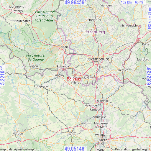
Belvaux GPS coordinates[2]
49° 30' 36.504" North, 5° 55' 26.904" East
| Map corner | latitude | longitude |
|---|---|---|
| Upper-left | 49.96456°, | 5.22101° |
| Center: | 49.51014°, | 5.92414° |
| Lower-right: | 49.05146°, | 6.62726° |
| Map W x H: | 101.5×101.5 km | = 63.1×63.1mi |
| max Lat: | 50.13722° ⇑93.2% North |
| Belvaux: | 49.51014° |
| min Lat: | ⇓6.8% South 49.45964° |
| min Long | Belvaux | max Long |
| 5.76583° | 5.92414° | 6.50532° |
| W 13.6%⇐ | ⇒86.4% E |
Elevation
Elevation of Belvaux is 339 m = 1112 ft, and this is 57 m = 187 ft above average elevation for this country.
| Max E: |
502 m = 1647 ft | 13% |
| Belvaux | 339 m 1112 ft | |
| Avg. | 282 m = 925 ft | |
Min E: |
143 m = 469 ft | 87% |
See also: Luxembourg elevation on elevation.city.
Geographical zone
Belvaux is located in North temperate zone (between Tropic of Cancer and the Arctic Circle). Distance of this North polar circle is 1896.2 km =1178.2 mi to North.| Distance of | km | miles | from Belvaux |
|---|---|---|---|
| North Pole | 4502.1 | 2797.5 | to North |
| Arctic Circle | 1896.2 | 1178.2 | to North |
| Tropic Cancer | 2899.1 | 1801.4 | to South |
| Equator | 5505 | 3420.6 | to South |


Nearby cities:
15 places around Belvaux: (largest is in red/bold)
• Bascharage
6.5 km =4 mi,  349°
349°
• Differdange
2.8 km =1.7 mi,  303°
303°
• Ehlerange
3.4 km =2.1 mi,  62°
62°
• Esch-sur-Alzette
4.4 km =2.7 mi,  111°
111°
• Hautcharage
7.3 km =4.5 mi, 351°
• Lamadelaine
6.3 km =3.9 mi,  309°
309°
• Linger
6.8 km =4.2 mi,  336°
336°
• Mondercange
5.3 km =3.3 mi, 61°
• Niedercorn
3.7 km =2.3 mi,  322°
322°
• Obercorn
2.1 km =1.3 mi,  280°
280°
• Pétange
6.2 km =3.9 mi,  329°
329°
• Rodange
7.2 km =4.5 mi, 303°
• Sanem
4.2 km =2.6 mi,  4°
4°
• Schifflange
6.4 km =4 mi,  93°
93°
• Soleuvre
1.6 km =1 mi,  38°
38°
Sources, notices
• [Note1] Compared only with cities in Luxembourg existing in our database
• [Src1] Map data: © OpenStreetMap contributors (CC-BY-SA)
• [Src2] Other city data from geonames.org with taken over terms of usage.
• [Src3] Geographical zone / Annual Mean Temperature by Robert A. Rohde @ Wikipedia
