Larochette geodata
Larochette (Mersch) is a seat of a third-order administrative division; located in Luxembourg in Europe/Luxembourg (GMT+2) time zone. With population of 1,410 people, there are 58 cities with bigger population in this country. Compared to other cities in Luxembourg, 75.1% of cities are located further ↓South; 70.6% of cities are located further ←West and 57.6% of cities have higher elevation than Larochette. Note1


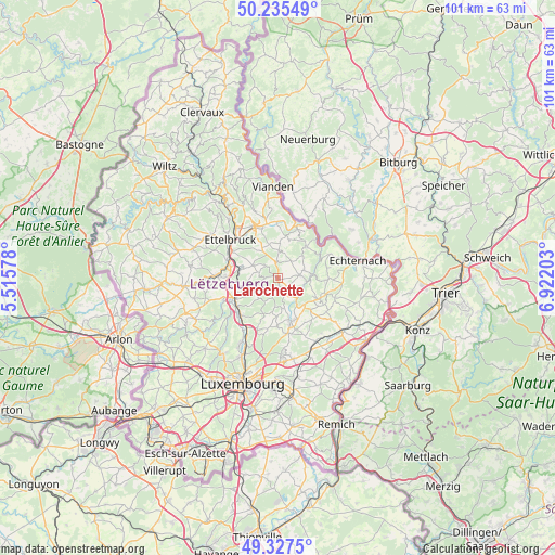
Larochette GPS coordinates[2]
49° 47' 1.032" North, 6° 13' 8.076" East
| Map corner | latitude | longitude |
|---|---|---|
| Upper-left | 50.23549°, | 5.51578° |
| Center: | 49.78362°, | 6.21891° |
| Lower-right: | 49.3275°, | 6.92203° |
| Map W x H: | 101×101 km | = 62.8×62.8mi |
| max Lat: | 50.13722° ⇑24.9% North |
| Larochette: | 49.78362° |
| min Lat: | ⇓75.1% South 49.45964° |
| min Long | Larochette | max Long |
| 5.76583° | 6.21891° | 6.50532° |
| W 70.6%⇐ | ⇒29.4% E |
Elevation
Elevation of Larochette is 273 m = 896 ft, and this is 9 m = 30 ft below average elevation for this country.
| Max E: |
502 m = 1647 ft | 57.6% |
| Avg. | 282 m = 925 ft | |
| Larochette | 273 m = 896 ft | |
Min E: |
143 m = 469 ft | 42.4% |
See also: Luxembourg elevation on elevation.city.
Geographical zone
Larochette is located in North temperate zone (between Tropic of Cancer and the Arctic Circle). Distance of this North polar circle is 1865.8 km =1159.4 mi to North.| Distance of | km | miles | from Larochette |
|---|---|---|---|
| North Pole | 4471.6 | 2778.5 | to North |
| Arctic Circle | 1865.8 | 1159.4 | to North |
| Tropic Cancer | 2929.5 | 1820.3 | to South |
| Equator | 5535.4 | 3439.5 | to South |


Nearby cities:
15 places around Larochette: (largest is in red/bold)
• Beaufort
7.8 km =4.8 mi,  41°
41°
• Beringen
7.8 km =4.8 mi,  248°
248°
• Bourglinster
9 km =5.6 mi,  180°
180°
• Colmar
9.2 km =5.7 mi,  288°
288°
• Consdorf
8.7 km =5.4 mi,  92°
92°
• Fischbach
4.8 km =3 mi,  208°
208°
• Gilsdorf
9.5 km =5.9 mi,  342°
342°
• Heffingen
2.2 km =1.4 mi,  136°
136°
• Junglinster
8.8 km =5.5 mi,  163°
163°
• Lintgen
9.3 km =5.8 mi,  223°
223°
• Medernach
2.9 km =1.8 mi,  354°
354°
• Mersch
9 km =5.6 mi,  244°
244°
• Nommern
3.2 km =2 mi,  276°
276°
• Rollingen
8.8 km =5.5 mi, 238°
• Waldbillig
4.9 km =3 mi,  73°
73°
Sources, notices
• [Note1] Compared only with cities in Luxembourg existing in our database
• [Src1] Map data: © OpenStreetMap contributors (CC-BY-SA)
• [Src2] Other city data from geonames.org with taken over terms of usage.
• [Src3] Geographical zone / Annual Mean Temperature by Robert A. Rohde @ Wikipedia
