Colmar geodata
Colmar (Mersch) is a section of populated place; located in Luxembourg in Europe/Luxembourg (GMT+2) time zone. With population of 1,776 people, there are 43 cities with bigger population in this country. Compared to other cities in Luxembourg, 80.2% of cities are located further ↓South; 53.7% of cities are located further →East and 75.1% of cities have higher elevation than Colmar. Note1


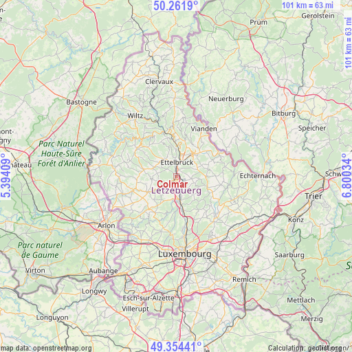
Colmar GPS coordinates[2]
49° 48' 37.008" North, 6° 5' 49.992" East
| Map corner | latitude | longitude |
|---|---|---|
| Upper-left | 50.2619°, | 5.39409° |
| Center: | 49.81028°, | 6.09722° |
| Lower-right: | 49.35441°, | 6.80034° |
| Map W x H: | 100.9×100.9 km | = 62.7×62.7mi |
| max Lat: | 50.13722° ⇑19.8% North |
| Colmar: | 49.81028° |
| min Lat: | ⇓80.2% South 49.45964° |
| min Long | Colmar | max Long |
| 5.76583° | 6.09722° | 6.50532° |
| W 46.3%⇐ | ⇒53.7% E |
Elevation
Elevation of Colmar is 237 m = 778 ft, and this is 45 m = 148 ft below average elevation for this country.
| Max E: |
502 m = 1647 ft | 75.1% |
| Avg. | 282 m = 925 ft | |
| Colmar | 237 m = 778 ft | |
Min E: |
143 m = 469 ft | 24.9% |
See also: Luxembourg elevation on elevation.city.
Geographical zone
Colmar is located in North temperate zone (between Tropic of Cancer and the Arctic Circle). Distance of this North polar circle is 1862.8 km =1157.5 mi to North.| Distance of | km | miles | from Colmar |
|---|---|---|---|
| North Pole | 4468.7 | 2776.7 | to North |
| Arctic Circle | 1862.8 | 1157.5 | to North |
| Tropic Cancer | 2932.5 | 1822.2 | to South |
| Equator | 5538.4 | 3441.4 | to South |


Nearby cities:
15 places around Colmar: (largest is in red/bold)
• Beringen
5.9 km =3.7 mi,  166°
166°
• Bissen
3.4 km =2.1 mi,  221°
221°
• Boevange-sur-Attert
7.2 km =4.5 mi,  234°
234°
• Diekirch
7.7 km =4.8 mi,  33°
33°
• Erpeldange
6.2 km =3.9 mi,  11°
11°
• Ettelbruck
4.2 km =2.6 mi, 6°
• Ingeldorf
5.4 km =3.4 mi, 30°
• Mersch
6.9 km =4.3 mi, 174°
• Mertzig
7 km =4.3 mi,  292°
292°
• Niederfeulen
6.2 km =3.9 mi,  324°
324°
• Nommern
6.1 km =3.8 mi,  115°
115°
• Reckange
6.8 km =4.2 mi,  188°
188°
• Schieren
2.3 km =1.4 mi,  2°
2°
• Vichten
7 km =4.3 mi,  263°
263°
• Warken
5.5 km =3.4 mi,  350°
350°
Sources, notices
• [Note1] Compared only with cities in Luxembourg existing in our database
• [Src1] Map data: © OpenStreetMap contributors (CC-BY-SA)
• [Src2] Other city data from geonames.org with taken over terms of usage.
• [Src3] Geographical zone / Annual Mean Temperature by Robert A. Rohde @ Wikipedia
