Heffingen geodata
Heffingen (Mersch) is a seat of a third-order administrative division; located in Luxembourg in Europe/Luxembourg (GMT+2) time zone. With population of 623 people, there are 129 cities with bigger population in this country. Compared to other cities in Luxembourg, 72.9% of cities are located further ↓South; 73.4% of cities are located further ←West and 79.1% of cities have lower elevation than Heffingen. Note1


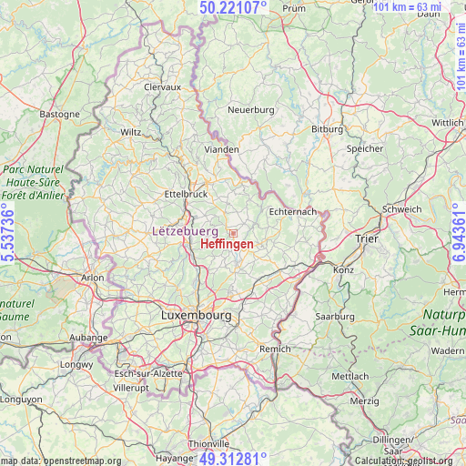
Heffingen GPS coordinates[2]
49° 46' 8.652" North, 6° 14' 25.764" East
| Map corner | latitude | longitude |
|---|---|---|
| Upper-left | 50.22107°, | 5.53736° |
| Center: | 49.76907°, | 6.24049° |
| Lower-right: | 49.31281°, | 6.94361° |
| Map W x H: | 101×101 km | = 62.8×62.8mi |
| max Lat: | 50.13722° ⇑27.1% North |
| Heffingen: | 49.76907° |
| min Lat: | ⇓72.9% South 49.45964° |
| min Long | Heffingen | max Long |
| 5.76583° | 6.24049° | 6.50532° |
| W 73.4%⇐ | ⇒26.6% E |
Elevation
Elevation of Heffingen is 325 m = 1066 ft, and this is 43 m = 141 ft above average elevation for this country.
| Max E: |
502 m = 1647 ft | 20.9% |
| Heffingen | 325 m 1066 ft | |
| Avg. | 282 m = 925 ft | |
Min E: |
143 m = 469 ft | 79.1% |
See also: Luxembourg elevation on elevation.city.
Geographical zone
Heffingen is located in North temperate zone (between Tropic of Cancer and the Arctic Circle). Distance of this North polar circle is 1867.4 km =1160.3 mi to North.| Distance of | km | miles | from Heffingen |
|---|---|---|---|
| North Pole | 4473.3 | 2779.6 | to North |
| Arctic Circle | 1867.4 | 1160.3 | to North |
| Tropic Cancer | 2927.9 | 1819.3 | to South |
| Equator | 5533.8 | 3438.5 | to South |


Nearby cities:
15 places around Heffingen: (largest is in red/bold)
• Beaufort
8.3 km =5.2 mi,  26°
26°
• Bech
9 km =5.6 mi,  101°
101°
• Berdorf
9.7 km =6 mi,  53°
53°
• Beringen
9 km =5.6 mi,  262°
262°
• Bourglinster
7.5 km =4.7 mi,  192°
192°
• Consdorf
7.2 km =4.5 mi,  80°
80°
• Fischbach
4.6 km =2.9 mi,  236°
236°
• Gonderange
8.2 km =5.1 mi,  177°
177°
• Junglinster
6.9 km =4.3 mi,  172°
172°
• Larochette
2.2 km =1.4 mi,  316°
316°
• Lintgen
9.5 km =5.9 mi, 236°
• Medernach
4.9 km =3 mi,  338°
338°
• Nommern
5.1 km =3.2 mi,  292°
292°
• Rollingen
9.6 km =6 mi,  251°
251°
• Waldbillig
4.4 km =2.7 mi, 46°
Sources, notices
• [Note1] Compared only with cities in Luxembourg existing in our database
• [Src1] Map data: © OpenStreetMap contributors (CC-BY-SA)
• [Src2] Other city data from geonames.org with taken over terms of usage.
• [Src3] Geographical zone / Annual Mean Temperature by Robert A. Rohde @ Wikipedia
