Schifflange geodata
Schifflange (Esch-sur-Alzette) is a seat of a third-order administrative division; located in Luxembourg in Europe/Luxembourg (GMT+2) time zone. With population of 8,155 people, there are 3 cities with bigger population in this country. Compared to other cities in Luxembourg, 94.9% of cities are located further ↑North; 68.9% of cities are located further →East and 55.4% of cities have lower elevation than Schifflange. Note1


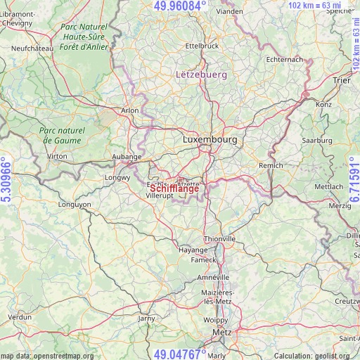
Schifflange GPS coordinates[2]
49° 30' 23.004" North, 6° 0' 46.008" East
| Map corner | latitude | longitude |
|---|---|---|
| Upper-left | 49.96084°, | 5.30966° |
| Center: | 49.50639°, | 6.01278° |
| Lower-right: | 49.04767°, | 6.71591° |
| Map W x H: | 101.5×101.5 km | = 63.1×63.1mi |
| max Lat: | 50.13722° ⇑94.9% North |
| Schifflange: | 49.50639° |
| min Lat: | ⇓5.1% South 49.45964° |
| min Long | Schifflange | max Long |
| 5.76583° | 6.01278° | 6.50532° |
| W 31.1%⇐ | ⇒68.9% E |
Elevation
Elevation of Schifflange is 292 m = 958 ft, and this is 10 m = 33 ft above average elevation for this country.
| Max E: |
502 m = 1647 ft | 44.6% |
| Schifflange | 292 m 958 ft | |
| Avg. | 282 m = 925 ft | |
Min E: |
143 m = 469 ft | 55.4% |
See also: Luxembourg elevation on elevation.city.
Geographical zone
Schifflange is located in North temperate zone (between Tropic of Cancer and the Arctic Circle). Distance of this North polar circle is 1896.6 km =1178.5 mi to North.| Distance of | km | miles | from Schifflange |
|---|---|---|---|
| North Pole | 4502.5 | 2797.7 | to North |
| Arctic Circle | 1896.6 | 1178.5 | to North |
| Tropic Cancer | 2898.7 | 1801.2 | to South |
| Equator | 5504.6 | 3420.4 | to South |


Nearby cities:
15 places around Schifflange: (largest is in red/bold)
• Belvaux
6.4 km =4 mi,  273°
273°
• Bergem
3 km =1.9 mi,  45°
45°
• Bettembourg
6.6 km =4.1 mi,  78°
78°
• Dudelange
6.1 km =3.8 mi,  118°
118°
• Ehlerange
3.9 km =2.4 mi,  300°
300°
• Esch-sur-Alzette
2.6 km =1.6 mi,  243°
243°
• Huncherange
3.9 km =2.4 mi,  72°
72°
• Kayl
2.7 km =1.7 mi,  134°
134°
• Mondercange
3.5 km =2.2 mi,  329°
329°
• Noertzange
3.1 km =1.9 mi, 84°
• Pontpierre
3.5 km =2.2 mi,  19°
19°
• Reckange-sur-Mess
6.2 km =3.9 mi,  357°
357°
• Rumelange
5.4 km =3.4 mi,  165°
165°
• Soleuvre
5.7 km =3.5 mi,  287°
287°
• Tétange
4 km =2.5 mi,  147°
147°
Sources, notices
• [Note1] Compared only with cities in Luxembourg existing in our database
• [Src1] Map data: © OpenStreetMap contributors (CC-BY-SA)
• [Src2] Other city data from geonames.org with taken over terms of usage.
• [Src3] Geographical zone / Annual Mean Temperature by Robert A. Rohde @ Wikipedia
