Pontpierre geodata
Pontpierre (Esch-sur-Alzette) is a populated place; located in Luxembourg in Europe/Luxembourg (GMT+2) time zone. With population of 1,009 people, there are 81 cities with bigger population in this country. Compared to other cities in Luxembourg, 84.2% of cities are located further ↑North; 66.7% of cities are located further →East and 58.2% of cities have lower elevation than Pontpierre. Note1


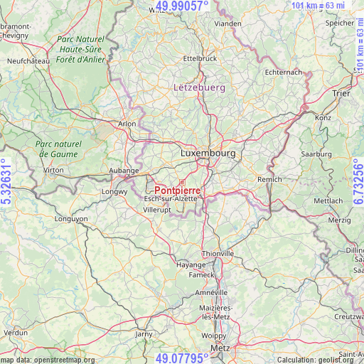
Pontpierre GPS coordinates[2]
49° 32' 11.004" North, 6° 1' 45.984" East
| Map corner | latitude | longitude |
|---|---|---|
| Upper-left | 49.99057°, | 5.32631° |
| Center: | 49.53639°, | 6.02944° |
| Lower-right: | 49.07795°, | 6.73256° |
| Map W x H: | 101.5×101.5 km | = 63.1×63.1mi |
| max Lat: | 50.13722° ⇑84.2% North |
| Pontpierre: | 49.53639° |
| min Lat: | ⇓15.8% South 49.45964° |
| min Long | Pontpierre | max Long |
| 5.76583° | 6.02944° | 6.50532° |
| W 33.3%⇐ | ⇒66.7% E |
Elevation
Elevation of Pontpierre is 295 m = 968 ft, and this is 13 m = 43 ft above average elevation for this country.
| Max E: |
502 m = 1647 ft | 41.8% |
| Pontpierre | 295 m 968 ft | |
| Avg. | 282 m = 925 ft | |
Min E: |
143 m = 469 ft | 58.2% |
See also: Luxembourg elevation on elevation.city.
Geographical zone
Pontpierre is located in North temperate zone (between Tropic of Cancer and the Arctic Circle). Distance of this North polar circle is 1893.2 km =1176.4 mi to North.| Distance of | km | miles | from Pontpierre |
|---|---|---|---|
| North Pole | 4499.1 | 2795.6 | to North |
| Arctic Circle | 1893.2 | 1176.4 | to North |
| Tropic Cancer | 2902 | 1803.2 | to South |
| Equator | 5507.9 | 3422.4 | to South |


Nearby cities:
15 places around Pontpierre: (largest is in red/bold)
• Bergem
1.6 km =1 mi,  143°
143°
• Bettange-sur-Mess
5.5 km =3.4 mi,  323°
323°
• Bettembourg
5.7 km =3.5 mi,  110°
110°
• Dippach
6.5 km =4 mi,  329°
329°
• Ehlerange
4.8 km =3 mi,  253°
253°
• Esch-sur-Alzette
5.7 km =3.5 mi,  218°
218°
• Huncherange
3.4 km =2.1 mi,  130°
130°
• Kayl
5.3 km =3.3 mi,  171°
171°
• Leudelange
4.4 km =2.7 mi,  36°
36°
• Mondercange
3 km =1.9 mi,  262°
262°
• Noertzange
3.6 km =2.2 mi,  147°
147°
• Reckange-sur-Mess
3.3 km =2.1 mi, 332°
• Schifflange
3.5 km =2.2 mi,  199°
199°
• Soleuvre
6.8 km =4.2 mi, 255°
• Tétange
6.8 km =4.2 mi, 172°
Sources, notices
• [Note1] Compared only with cities in Luxembourg existing in our database
• [Src1] Map data: © OpenStreetMap contributors (CC-BY-SA)
• [Src2] Other city data from geonames.org with taken over terms of usage.
• [Src3] Geographical zone / Annual Mean Temperature by Robert A. Rohde @ Wikipedia
