Mersch geodata
Mersch is a seat of a first-order administrative division; located in Luxembourg in Europe/Luxembourg (GMT+2) time zone. With population of 3,464 people, there are 23 cities with bigger population in this country. Compared to other cities in Luxembourg, 69.5% of cities are located further ↓South; 51.4% of cities are located further →East and 83.6% of cities have higher elevation than Mersch. Note1


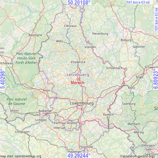
Mersch GPS coordinates[2]
49° 44' 56.004" North, 6° 6' 21.996" East
| Map corner | latitude | longitude |
|---|---|---|
| Upper-left | 50.20108°, | 5.40298° |
| Center: | 49.74889°, | 6.10611° |
| Lower-right: | 49.29244°, | 6.80923° |
| Map W x H: | 101×101 km | = 62.8×62.8mi |
| max Lat: | 50.13722° ⇑30.5% North |
| Mersch: | 49.74889° |
| min Lat: | ⇓69.5% South 49.45964° |
| min Long | Mersch | max Long |
| 5.76583° | 6.10611° | 6.50532° |
| W 48.6%⇐ | ⇒51.4% E |
Elevation
Elevation of Mersch is 219 m = 719 ft, and this is 63 m = 207 ft below average elevation for this country.
| Max E: |
502 m = 1647 ft | 83.6% |
| Avg. | 282 m = 925 ft | |
| Mersch | 219 m = 719 ft | |
Min E: |
143 m = 469 ft | 16.4% |
See also: Luxembourg elevation on elevation.city.
Geographical zone
Mersch is located in North temperate zone (between Tropic of Cancer and the Arctic Circle). Distance of this North polar circle is 1869.6 km =1161.7 mi to North.| Distance of | km | miles | from Mersch |
|---|---|---|---|
| North Pole | 4475.5 | 2780.9 | to North |
| Arctic Circle | 1869.6 | 1161.7 | to North |
| Tropic Cancer | 2925.6 | 1817.9 | to South |
| Equator | 5531.6 | 3437.2 | to South |


Nearby cities:
15 places around Mersch: (largest is in red/bold)
• Beringen
1.3 km =0.8 mi,  36°
36°
• Bissen
5.2 km =3.2 mi,  325°
325°
• Boevange-sur-Attert
7 km =4.3 mi,  291°
291°
• Bofferdange
6.9 km =4.3 mi,  159°
159°
• Brouch
6.1 km =3.8 mi,  256°
256°
• Colmar
6.9 km =4.3 mi,  354°
354°
• Fischbach
5.8 km =3.6 mi,  93°
93°
• Helmdange
6.6 km =4.1 mi, 157°
• Keispelt
6.7 km =4.2 mi,  204°
204°
• Lintgen
3.4 km =2.1 mi,  149°
149°
• Lorentzweiler
5.9 km =3.7 mi, 153°
• Nommern
6.5 km =4 mi,  49°
49°
• Reckange
1.7 km =1.1 mi,  273°
273°
• Rollingen
1 km =0.6 mi,  143°
143°
• Tuntange
7.7 km =4.8 mi,  243°
243°
Sources, notices
• [Note1] Compared only with cities in Luxembourg existing in our database
• [Src1] Map data: © OpenStreetMap contributors (CC-BY-SA)
• [Src2] Other city data from geonames.org with taken over terms of usage.
• [Src3] Geographical zone / Annual Mean Temperature by Robert A. Rohde @ Wikipedia
